

 September 14th, 2016
  Riffin
 - Published: June 10, 2015
- http://dx.doi.org/10.1371/journal.pone.0126946
In the last decade, paleoclimatology has been amongst the most rapidly developing research fields within the Earth Sciences. Crucial information that can be derived from geological records include the relationships between atmospheric chemical composition and global temperature, meridional temperature gradients, and regional and global sea level change, as well as the response of the global exogenic system to perturbations in ocean acidity and oxygenation [1]. Such studies ultimately aim at improving projections of future climate and ecosystem changes resulting from human emissions of carbon and nutrients.
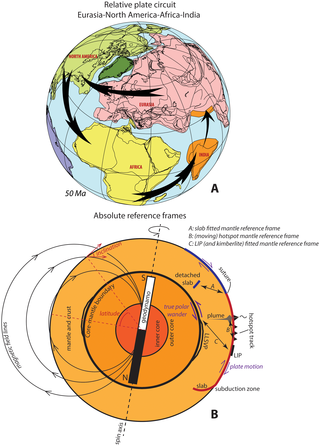
(A) Example of a plate circuit. The motion of India versus Eurasia cannot be directly constrained since these plates are bounded by a destructive plate boundary (trench). Relative motions between these plates can be reconstructed by restoring the opening history of the North Atlantic ocean between Eurasia and North America, the Central Atlantic Ocean between Africa and North America, and the Indian Ocean between India and Africa. With the relative positions of all these plates known through time, a paleomagnetic pole of one of these plates can be used to constrain all of these plates relative to the geodynamo. (B) schematic outline of plate and mantle motions and reference frames. Plates move relative to the mantle (plate tectonics), and plates and mantle together can undergo phases of motion relative to the liquid outer core (true polar wander). Both processes lead to motion of a rock record relative to the Earth’s spin axis, and hence both influence the angle of insolation that is relevant for paleoclimate study. Mantle reference frames A-C (see text for explanation of these frames) can only reconstruct plate motion relative to the mantle, but cannot reconstruct true polar wander. These frames are therefore used for analysis of geodynamics, but should not be used for paleoclimate studies. Instead, a paleomagnetic reference frame should be used. On geological timescales, the geodynamo coincides with the Earth’s spin axis. The orientation of the paleomagnetic field in a rock can be used to restore a rock record into its original paleolatitude relative to the spin axis.
http://dx.doi.org/10.1371/journal.pone.0126946.g001
A crucial aspect of paleoclimate reconstructions based on geological proxy data is a correct representation of paleogeography, notably continent-ocean configuration and latitude. Continent-ocean configuration partially determines the distribution of energy across the Earth’s surface via ocean and atmosphere circulation. To accurately reconstruct past climate change, it is therefore essential to accurately constrain the paleogeographical position of a geological record, sampled at a drill site or an exposed sedimentary section, at the moment of deposition. For instance, a measurable/reconstructable (paleo-)climate parameter that provides key information to compare with theory (i.e., climate models) is the meridional temperature gradient. Many of such paleotemperature gradients have been reconstructed, e.g., for the Eocene [2–5]. However, for proper interpretation and comparison to numerical model predictions, the precise position, paleolatitude, and geography of the study sites, as well as the uncertainty on such numbers, must be optimally constrained to assess e.g., solar insolation and its position relative to expected ocean and atmosphere circulation patterns that potentially cause regional variations.
To incorporate the effect of plate tectonic changes, the relative motions of plates are reconstructed using marine magnetic anomalies and fracture zones of the ocean floor. Widely used reconstructions in the paleoclimate community are for instance those of Hay and colleagues [6], Scotese [7], and Müller and colleagues [8]. Using these reconstructions, so-called relative plate motion chains [9] are built that incorporate the relative motions of present and former plates that are or were bounded by mid-ocean ridges.
Such relative plate motion chains, which may be closed into a plate circuit, may be a sufficient reference frame to study the kinematic evolution of a destructive plate boundary, such as the India-Asia plate boundary in the Himalaya. For many other studies, however, it is key to determine the position of the plate circuit relative to the Earth’s spin axis, or to the mantle. To this end, ‘absolute’ reference frames have been developed. Paleoclimate studies require knowledge of the location of a studied sedimentary archive during its deposition relative to the Earth’s spin axis, as this determined its position relative to the sun, and thus its climate.
Below, we illustrate that reference frames reconstructing plates relative to the mantle can considerably differ from frames reconstructing plates relative to the spin axis (perhaps as much as 15° (i.e. ~1650 km) in the Early Cenozoic [10] and more than 20° (>2200 km) in the Mesozoic [11]) due to a process known as ‘true polar wander’. These differences may become important at critical time intervals and specific locations on Earth, for instance close to 60° paleolatitude, where even slight differences in paleolatitude determine whether a given site was in easterly versus westerly winds [12] and it is thus essential to use a reference frame relative to the Earth’s spin axis.
The notion, and importance of using the appropriate reference frame for paleoclimate studies, however, seems somewhat underappreciated in the literature. Most paleoclimate studies do not specify the reference frame that is used to determine the paleolatitude. In more recent literature (e.g., [3]), reference is frequently made to freely online available Gplates reconstruction software [13]. This software package comes with a state-of-the-art relative global plate reconstruction [14], and as default a mantle reference frame [15], which is appropriate for geodynamic problems, but, as we will explain, not for paleoclimate studies. As a consequence, while the effects of the obliquity of the Earth axis that correspond to variations of ~2° are carefully taken into account, the potential uncertainty introduced by misplacement of a study site due to an inappropriate reference frame may be one order of magnitude larger for paleoclimate studies going far back into geological time.
In this paper, we summarize the procedures underlying plate tectonic reconstructions and reference frame generation, and identify which reference frames should be used for various Earth scientific problems. In addition, we describe and provide an online tool (available atwww.paleolatitude.org) that we developed to determine the paleolatitude within all major plates and plate fragments, allowing a user to determine the paleolatitude and associated error bars relative to the Earth’s spin axis, tailor-made for paleoclimate analyses of Jurassic and younger times. Finally, we will show a case study in Cenozoic global temperature reconstructions to illustrate the importance of using the appropriate reference frame, and the use of the provided paleolatitude calculator.
@WFS,World Fossil Society,Riffin T Sajeev,Russel T Sajeev
 Posted in
  Tags:
Tags: 