

 February 6th, 2017
  Riffin
 @ WFS,World Fossil Society,Riffin T Sajeev,Russel T Sajeev
Scientists have confirmed the existence of a “lost continent” under the Indian Ocean island of Mauritius that was left-over by the break-up of the supercontinent, Gondwana, which started about 200 million years ago. The piece of crust, which was subsequently covered by young lava during volcanic eruptions on the island, seems to be a tiny piece of ancient continent, which broke off from the island of Madagascar, when Africa, India, Australia and Antarctica split up and formed the Indian Ocean. “We are studying the break-up process of the continents, in order to understand the geological history of the planet,” says Wits geologist, Professor Lewis Ashwal, lead author on the paper “Archaean zircons in Miocene oceanic hotspot rocks establish ancient continental crust beneath Mauritius,” published in the journal Nature Communications.
By studying the mineral, zircon, found in rocks spewed up by lava during volcanic eruptions, Ashwal and his colleagues Michael Wiedenbeck from the German Research Centre for Geosciences (GFZ) and Trond Torsvik from the University of Oslo, guest scientist at GFZ, have found that remnants of this mineral were far too old to belong on the island of Mauritius.
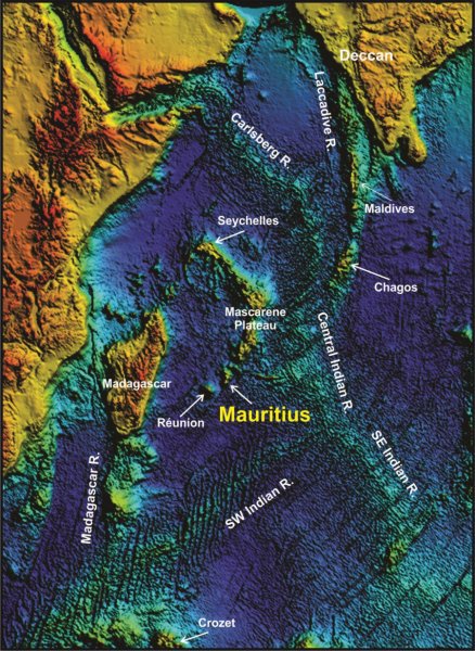
This is Indian Ocean topography showing the location of Mauritius as part of a chain of progressively older volcanoes extending from the presently active hot-spot of Réunion toward the 65-million-year-old Deccan traps of northwest India.Credit: Wits University
“Earth is made up of two parts — continents, which are old, and oceans, which are “young.” On the continents you find rocks that are over four billion years old, but you find nothing like that in the oceans, as this is where new rocks are formed,” explains Ashwal. “Mauritius is an island, and there is no rock older than 9 million years old on the island. However, by studying the rocks on the island, we have found zircons that are as old as 3 billion years.”
Zircons are minerals that occur mainly in granites from the continents. They contain trace amounts of uranium, thorium and lead, and due to the fact that they survive geological process very well, they contain a rich record of geological processes and can be dated extremely accurately.

Mauritius (M) is reconstructed in a likely location near Archaean–Neoproterozoic rocks in central-east Madagascar just prior to break-up2. The exact size and geometries of Mauritius and other potential Mauritian continental fragments (collectively known as Mauritia, including SM Saya de Malha; C, Chagos; CC, Cargados-Carajos Banks; LAC, Laccadives; N, Nazreth; see present location in Fig. 6) are unknown, and are generously drawn in the diagram. We propose that Mauritia is dominantly underlain by Archaean continental crust, and part of the ancient nucleus of Madagascar25,46 and India20,21 (stippled black line). A Large Igneous Province event (linked to the Marion plume) occurred from 92 to 84 Ma, and most of Madagascar was covered with flood basalts (full extent not shown for simplicity). Blue stippled line indicates the site of Cretaceous pre-breakup strike-slip faulting. AG, Analava gabbro (91.6 Ma); LR, Laxmi Ridge; S, Seychelles; SM, St Mary rhyolites (91.2 Ma)41. The black–white box (geology of Madagascar) is enlarged in the inset to Fig. 5. Inset map shows simplified geology of Mauritius, including trachyte plugs7. Star symbol marked MAU-8 is the sampling area for the present study and black bars indicate locations of zircons recovered from beach sand samples2.
“The fact that we have found zircons of this age proves that there are much older crustal materials under Mauritius that could only have originated from a continent,” says Ashwal.
This is not the first time that zircons that are billions of years old have been found on the island. A study done in 2013 has found traces of the mineral in beach sand. However, this study received some criticism, including that the mineral could have been either blown in by the wind, or carried in on vehicle tyres or scientists’ shoes.

These three grains were recovered from the MAU-8 trachyte sample. Backscattered electron (BSE) images (a–c) of the three grains taken after completing all U–Th–Pb isotopic analyses. Cathodoluminescence (CL) images (d–f) taken prior to acquiring our SIMS data. The indicated analysis numbers correspond to those in Supplementary Data 1. The indicated ages are the radiogenic 207Pb/206Pb ages for the corresponding craters.
“The fact that we found the ancient zircons in rock (6-million-year-old trachyte), corroborates the previous study and refutes any suggestion of wind-blown, wave-transported or pumice-rafted zircons for explaining the earlier results,” says Ashwal.
Ashwal suggests that there are many pieces of various sizes of “undiscovered continent,” collectively called “Mauritia,” spread over the Indian Ocean, left over by the breakup of Gondwanaland.
“According to the new results, this break-up did not involve a simple splitting of the ancient super-continent of Gondwana, but rather, a complex splintering took place with fragments of continental crust of variable sizes left adrift within the evolving Indian Ocean basin.”
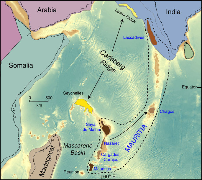
These include Mauritia (brownish shading), Laxmi Ridge and the Seychelles (yellowish shading). During the opening of the Mascarene Basin at about 84 Ma, India, together with most of Mauritia and the Seychelles/Laxmi Ridge, broke away from Madagascar. Mauritia was subsequently fragmented into a ribbon-like configuration because of a series of mid-ocean ridge jumps2, which were partly related to the Marion plume and later the Reunion plume (after 66 Ma). The current configuration with Mauritius/Cargados-Carajos Banks/Nazareth/Saya de Malha forming the Southern Mascarene Plateau (part of the African/Somali Plate), and with the Laccadives and Chagos being part of the Indian Plate, arose at 41 Ma (black arrow shows where Chagos originated at 41 Ma). North of Mauritia, seafloor spreading was initiated between the Laxmi Ridge and the Seychelles at around 62–63 Ma, and the Seychelles became part of the African/Somalian plate after 61 Ma when seafloor spreading in the Mascarene Basin ceased2. Background bathymetry is ETOPO147 and continental plate polygons with continental-ocean boundaries are from Torsvik & Cocks48.
@ WFS,World Fossil Society,Riffin T Sajeev,Russel T Sajeev
Journal Reference:Lewis D. Ashwal, Michael Wiedenbeck, Trond H. Torsvik. Archaean zircons in Miocene oceanic hotspot rocks establish ancient continental crust beneath Mauritius. Nature Communications, 2017; 8: 14086 DOI: 10.1038/ncomms14086
Citation:University of the Witwatersrand. “Researchers confirm the existence of a ‘lost continent’ under Mauritius.” ScienceDaily. ScienceDaily, 31 January 2017. <www.sciencedaily.com/releases/2017/01/170131124126.htm>.
 Posted in
  Tags:
Tags: 