The 2011 Mineral, Virginia M-5.8 earthquake was felt over an extraordinarily large area. A new study details landslides triggered by the earthquake at distances four times greater and over an area 20 times larger than previously
The study, to be published in the December issue of the Bulletin of the Seismological Society of America(BSSA), describes physical confirmation of previous observations that ground shaking from earthquakes in the eastern U.S. travels farther than in the western U.S, a plate-boundary region.

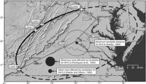
The star indicates the epicenter; large crosses are landslide limits; the small cross represents the largest landslide observed; triangles represent seismic recording stations with station codes indicated (see Table 1 for station names and codes); and dash-double-dot lines are state boundaries. The bold line shows a best-fit ellipse centered at the epicenter and passing through the observed limits (dashed where inferred beyond limits); the dotted line shows a polygon enclosing the observed landslides; the circle around the epicenter indicates the previous maximum distance limit for M 5.8 earthquake (Keefer, 1984); filled circles show maximum (1500 km2) and average (219 km2) areas expected to experience landslides for an M 5.8 earthquake based on previous studies (Keefer, 1984, 2002; Rodríguez et al., 1999). Sinuous solid line shows Blue Ridge Parkway, which extends along the crest of the Blue Ridge. Abundant susceptible slopes exist from the Blue Ridge to the west and north; few susceptible slopes are present to the south and east. (Credit: BSSA Vol. 102:6
U.S. Geological Survey scientists Randall W. Jibson, who is scheduled to present his findings on Nov. 6 at the annual meeting of the Geological Society of America, and co-author Edwin L. Harp painstakingly mapped rock falls to determine the distance limits from the epicenter to compare with previously documented earthquakes.
The 2011 Virginia earthquake was the largest earthquake in the eastern U.S. since 1897. Although it did not produce large, damaging landslides, it did trigger small landslides of rock and soil from steep slopes.
Because landslides can occur without earthquake shaking, Jibson and Harp looked for evidence of recent physical disruption that could be attributed to the quake. From August 25 though September 3, Jibson and Harp made detailed observations by driving outward from the epicentral area in transects; they stopped frequently to get on their hands and knees to overturn rocks to see whether there was green grass underneath — a sign that the rock could have fallen during the quake. As they drove, they inspected highly susceptible slopes until they had reached an apparent limit for a particular area.
“We’ve been doing this for more than 30 years and have developed a consistent observational standard that isn’t dependent on the observers,” Jibson said. “We are confident we can accurately compare limits for different earthquakes.”
The authors noted that Hurricane Irene passed near the area a few days after the quake, and they identified small rainfall-triggered debris flows that were quite distinct from rock falls triggered by the quake.
Landslide limits were documented along the Blue Ridge Parkway from near Harpers Ferry, West Virginia, southwestward to within 30 km of the Virginia-North Carolina border as well as on transects northwestward through the Appalachian Mountains into West Virginia. The limits to the east and south of the Blue Ridge are less well constrained owing to a lack of susceptible slopes. The authors propose an estimated elliptical area had there been equally susceptible landscape yielding evidence in all areas.
There is sufficient documented evidence, say Jibson and Harp, to suggest the need to revise the established distance limits for the occurrence of landslides in different tectonic environments.
For the eastern U.S., the documented landslides from the 2011 Virginia earthquake suggest that ground motion is stronger and travels farther parallel to the Appalachian Mountains than perpendicular to them, which is consistent with other sources of intensity information such as the U.S. Geological Survey’s Did You Feel It? map.
Not all historical post-earthquake landslide investigations have been conducted at the same level of detail, and so they might not be directly comparable with the current study. Also, very few earthquakes in stable continental interiors, where ground motion is known to travel farther than in plate-boundary regions, have had thorough documentations of triggered landslides, noted the authors.
“Even taking differential landslide reporting into account,” wrote the authors, “the landslide limits from the 2011 Virginia earthquake are extraordinary.”
The study is titled, “Extraordinary Distance Limits of Landslides Triggered by the 2011 Mineral, Virginia Earthquake.”


 November 14th, 2012
  Riffin
  Posted in
  Tags:
Tags: 