Tall buildings, bridges and other long-period structures in Greater Vancouver may experience greater shaking from large (M 6.8 +) earthquakes than previously thought due to the amplification of surface waves passing through the Georgia basin, according to two studies published by the Bulletin of the Seismological Society of America (BSSA). The basin will have the greatest impact on ground motion passing over it from earthquakes generated south and southwest of Vancouver.
“For very stiff soils, current building codes don’t include amplification of ground motion,” said lead author Sheri Molnar, a researcher at the University of British Columbia. “While the building codes say there should not be any increase or decrease in ground motion, our results show that there could be an average amplification of up to a factor of three or four in Greater Vancouver.”
The research provides the first detailed studies of 3D earthquake ground motion for a sedimentary basin in Canada. Since no large crustal earthquakes have occurred in the area since the installation of a local seismic network, these studies offer refined predictions of ground motion from large crustal earthquakes likely to occur.
Southwestern British Columbia is situated above the seismically active Cascadia subduction zone. A complex tectonic region, earthquakes occur in three zones: the thrust fault interface between the Juan de Fuca plate, which is sliding beneath the North America plate; within the over-riding North America plate; and within the subducting Juan de Fuca plate.
Molnar and her colleagues investigate the effect the three dimensional (3D) deep basin beneath Greater Vancouver has on the earthquake-generated waves that pass through it. The Georgia basin is one in a series of basins spanning form California to southern Alaska along the Pacific margin of the North America and is relatively wide and shallow. The basin is filled with sedimentary layers of silts, sands and glacial deposits.
While previous research suggested how approximately 100 meters of material near the surface would affect ground shaking, no studies had looked at the effect of the 3D basin structure on long period seismic waves.
To fill in that gap in knowledge, Molnar and colleagues performed numerical modeling of wave propagation, using various scenarios for both shallow quakes (5 km in depth) within the North America plate and deep quakes (40 — 55 km in depth) within the Juan de Fuca subducting plate, the latter being the most common type of earthquake. The authors did not focus on earthquakes generated by a megathrust rupture of the Cascadia subduction zone, a scenario studied previously by co-author Kim Olsen of San Diego State University.
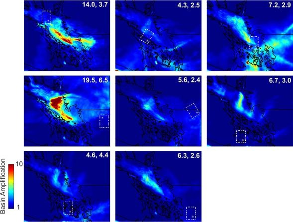
For these two studies, the authors modeled 10 scenario earthquakes for the subducting plate and 8 shallow crustal earthquakes within the North America plate, assuming rupture sites based on known seismicity. The computational analyses suggest the basin distorts the seismic radiation pattern — how the energy moves through the basin — and produces a larger area of higher ground motions. Steep basin edges excite the seismic waves, amplifying the ground motion.

Multiple scenarios for earthquakes within the Georgia Basin underneath Vancouver indicate that earthquakes would be amplified.
Credit: Sheri Molnar and Kim Olsen
The largest surface waves generated across Greater Vancouver are associated with earthquakes located approximately 80 km or more, south-southwest of the city, suggest the authors.
“The results were an eye opener,” said Molnar. “Because of the 3D basin structure, there’s greater hazard since it will amplify ground shaking. Now we have a grasp of how much the basin increases ground shaking for the most likely future large earthquakes.”
In Greater Vancouver, there are more than 700 12-story and taller commercial and residential buildings, and large structures — high-rise buildings, bridges and pipelines — that are more affected by long period seismic waves, or long wavelength shaking. “That’s where these results have impact,” said Molnar.


 February 17th, 2014
  Riffin
  Posted in
  Tags:
Tags: 