New Permian Fish Discovered in Brazil

Dr. Eliseu Vieira Dias of the State University of Western Paraná (UNIOESTE) has announced the discovery of a new species of deep-bodied fish that prowled ancient rivers and lakes in the South American part of Gondwana during Permian period.


Paranaichthys longianalis

Paranaichthys longianalis

A fossil of Paranaichthys longianalis (E.V. Dias)

A paper in the journal Zootaxa describes a new species of deep-bodied fossil fish, called Paranaichthys longianalis, which also represents a new genus belonging to the Actinopterygii (the largest subclass of ray-finned fishes).

A single fossilized specimen of P. longianalis was collected from the Rio do Rasto Formation in Paraná Basin, Brazil.

“As mentioned in the paper, the single specimen of this fossil fish was discovered in 1989 by Dr. Rosemarie Rohn of the State University of Paulista,” Dr. Dias explained in the interview with Sci-News.com. “Dr. Rohn found the specimen in waste pile of a small mine. The fossil was preserved in the collection of the Museum of Science and Technology in Porto Alegre, Brazil.”

“The discovery was for the first time presented in 1996. Now, some features of the new fish have been revised and appeared in Zootaxa.”

The researcher noted that this fossil fish lived in freshwater habits in the southwestern part of Gondwana about 268-260 million years ago (the Upper Permian).

P. longianalis is a deep-bodied fish that has an elongated anal fin (deep-bodied fishes are those of laterally compressed body shapes, usually as tall as long),” Dr. Dias said. “The cranial features are poorly preserved in the specimen. However, the presence of crushing dentition indicates a hard-food diet for this species.”

“This crushing dentition presents a small cap of an enameloid tissue known as verruciform acrodin”, Dr. Dias explained. “The scales are ganoid with a three layer organization, in which the inner layer is composed of bone tissue, the intermediate is dentine and the external is enamel (ganoine). The flank scales are high, a pattern common in deep-bodied fishes.”

P. longianalis measured about 8.5 inches (21.5 cm) and had remarkably large and long anal fin, a feature unknown in all other deep-bodied actinopterygians.

The name of the species refers to this remarkable fin, while the genus name refers to the Paraná sedimentary Basin, where the fossil was found.

This fossil fish probably lived together with other actinopterygians, amphibian temnospondyls such asAustralerpeton cosgriffi, chondrichthyans and dipnoans. It would have been able to develop short fast movements using its strong caudal peduncle and well-developed caudal fin.

“This is the second actinopterygian species, described from the Rio do Rasto Formation in Paraná Basin, and the first deep-bodied”, Dr. Dias concluded. “This geological formation is in the focus of several researches and many new fossil taxa described, including the discovery of carnivorous dinocephalian by Cisneros et al. in 2012, which is not cited in my paper. The knowledge of this fossil fauna can provide a more complete reconstruction of the Middle-Upper Permian in the western Pangea paleoenvironments.”

When continents collide: A new twist to a 50 million-year-old tale

Fifty million years ago, India slammed into Eurasia, a collision that gave rise to the tallest landforms on the planet, the Himalaya Mountains and the Tibetan Plateau.

India and Eurasia continue to converge today, though at an ever-slowing pace. University of Michigan geomorphologist and geophysicist Marin Clark wanted to know when this motion will end and why. She conducted a study that led to surprising findings that could add a new wrinkle to the well-established theory of plate tectonics – the dominant, unifying theory of geology.

“The exciting thing here is that it’s not easy to make progress in a field (plate tectonics) that’s 50 years old and is the major tenet that we operate under,” said Clark, an assistant professor in the Department of Earth and Environmental Sciences in the College of Literature, Science, and the Arts.

“The Himalaya and Tibet are the highest mountains today on Earth, and we think they’re probably the highest mountains in the last 500 million years,” she said. “And my paper is about how this is going to end and what’s slowing down the Indian plate.”

Clark’s paper is scheduled for online publication Feb. 29 in the journal Nature.

In it, she suggests that the strength of the underlying mantle, not the height of the mountains, is the critical factor that will determine when the Himalayan-Tibetan mountain-building episode ends. The Earth’s mantle is the thick shell of rock that separates the crust above from the core below.

According to the theory of plate tectonics, the outer part of the Earth is broken into several large plates, like pieces of cracked shell on a boiled egg. The continents ride on the plates, which move relative to one another and occasionally collide. The tectonic plates move about as fast as your fingernails grow, and intense geological activity – volcanoes, earthquakes and mountain-building, for example – occurs at the plate boundaries.

The rate at which the Indian sub-continent creeps toward Eurasia is slowing exponentially, according to Clark, who reviewed published positions of northern India over the last 67 million years to evaluate convergence rates. The convergence will halt – putting an end to one of the longest periods of mountain-building in recent geological history – in about 20 million years, she estimates.

And what will cause it to stop?

Until now, conventional wisdom among geologists has been that the slowing of convergence at mountainous plate boundaries was related to changes in the height of the mountains. As the mountains grew taller, they exerted an increasing amount of force on the plate boundary, which slowed the convergence.

But in her Nature paper, Clark posits that a different model, one based on the strength of the uppermost mantle directly beneath the mountains, best explains the observed post-collisional motions of the Indian plate.

By “strength” Clark means the uppermost mantle’s ability to withstand deformation, a property called viscous resistance. Clark suggests that the relatively strong mantle directly beneath Tibet and the Himalayas acts as a brake that slows – and will eventually halt – the convergence of the two continents.

“My paper is arguing that it’s not the height of the mountains, it’s the strength of the mantle that’s controlling this slowing,” Clark said. “This is something that hasn’t been considered before and basically grew out of field observations in northern Tibet.”

But viscous resistance doesn’t tell the whole story. Other factors may also contribute to the slowing of the Indian plate, Clark said.

“For me, critical field observations showed that the northern edge of the Tibetan Plateau hasn’t moved since the collision 50 million years ago,” she said. “Therefore, the Tibetan Plateau is getting smaller in width. It’s like squeezing a box and making it narrower while squeezing it up.”

The rate at which the box is being squeezed is the average rate of mountain-building, and it provides important clues about the factors controlling plate motion. Clark analyzed how the convergence is slowing as compared to the shrinking of the plateau.

“If the height of the mountains were important in slowing India’s convergence, then the rate of mountain-building should also slow down as the Himalaya and Tibet grew to high elevation,” Clark said. “But when I analyzed how the mountain-building rate changed over the past 50 million years, I was surprised to find that it didn’t change at all.

“From this I conclude that the strength of the uppermost mantle is keeping this mountain- building constant. But as the box is shrinking, the plate motion must slow down to keep the shrinking rate the same,” she said.

Note: This story has been adapted from a news release issued by the University of Michigan


Tibetan Plateau May Be Older Than Previously Thought

The growth of high topography on the Tibetan Plateau in Sichuan, China, began much earlier than previously thought, according to an international team of geologists who looked at mountain ranges along the eastern edge of the plateau.

The Indian tectonic plate began its collision with Asia between 55 and 50 million years ago, but “significant topographic relief existed adjacent to the Sichuan Basin prior to the Indo-Asian collision,” the researchers report online in Nature Geoscience.

Tibetan Plateau

Tibetan Plateau

“Most researchers have thought that high topography in eastern Tibet developed during the past 10 to 15 million years, as deep crust beneath the central Tibetan Plateau flowed to the plateau margin, thickening Earth’s crust in this area and causing surface uplift,” said Eric Kirby, associate professor of geoscience at Penn State. “Our study suggests that high topography began to develop as early as 30 million years ago, and perhaps was present even earlier.”

Kirby, working with Erchie Wang of the Institute of Geology and Geophysics at the Chinese Academy of Sciences in Beijing; Kevin Furlong, professor of geosciences at Penn State; and colleagues from Waikato University, New Zealand and Arizona State University, looked at samples taken from the hanging wall of the Yingxiu-Beichuan fault, the primary fault responsible for the 2008, Wenchuan earthquake. The researchers used a variety of methods including the decay rate of uranium and thorium to helium in the minerals apatite and zircon and fission track dating, an analysis of tracks or trails left by decaying uranium in minerals again in apatite and zircon.

“These methods allow us to investigate the thermal regime from about 250 degrees Celsius (482 degrees Fahrenheit) to about 60 degrees (140 degrees Fahrenheit),” said Kirby. “The results show that the rocks cooled relatively slowly during the early and mid-Cenozoic — from 30 to 50 million years ago — an indication that topography in the region was undergoing erosion.”

The results also suggest that gradual cooling during this time was followed by two episodes of rapid erosion, one beginning 30 to 25 million years ago and one beginning 15 to 10 million years ago that continues today.

“These results challenge the idea that the topographic relief along the margin of the plateau developed entirely in the Late Miocene, 5 to 10 million years ago,” said Kirby. “The period of rapid erosion between 25 to 30 million years ago could only be sustained if the mountains were not only present, but actively growing, at this time.”

The researchers also note that this implies that fault systems responsible for the 2008 earthquake were also probably active early in the history of the growth of the Tibetan Plateau.

“We are still a long way from completely understanding when and how high topography in Asia developed in response to India-Asia collision,” notes Kirby. “However, these results lend support to the idea that much of what we see today in the mountains of China may have developed earlier than we previously thought.”

The Chinese National Key Projects Program, the National Natural Science Foundation of China and the National Science Foundation funded this research.


Plant-Eating Dinosaur Discovered in Antarctica

For the first time, the presence of large bodied herbivorous dinosaurs in Antarctica has been recorded. Until now, remains of sauropoda — one of the most diverse and geographically widespread species of herbivorous dinosaurs — had been recovered from all continental landmasses, except Antarctica. Dr. Ignacio Alejandro Cerda, from CONICET in Argentina, and his team’s identification of the remains of the sauropod dinosaur suggests that advanced titanosaurs (plant-eating, sauropod dinosaurs) achieved a global distribution at least by the Late Cretaceous*.

bones of sauropada

bones of sauropada

Their work has just been published online in Springer’s journalNaturwissenschaften – The Science of Nature.

Sauropoda is the second most diverse group of dinosaurs, with more than 150 recognized species. It includes the largest terrestrial vertebrates that ever existed. Although many sauropod remains have been discovered in North and South America, Africa, Asia, Australia and Europe, there is no previous record of sauropoda in Antarctica. Other important dinosaur discoveries have been made in Antarctica in the last two decades — principally in the James Ross Basin.Dr. Cerda and colleagues report the first finding of a sauropod dinosaur from this continent and provide a detailed description of an incomplete middle-tail vertebra, recovered from James Ross Island. The specific size and morphology of the specimen, including its distinctive ball and socket articulations, lead the authors to identify it as an advanced titanosaur.

These titanosaurs originated during the Early Cretaceous and were the predominant group of sauropod dinosaurs until the extinction of all non-bird dinosaurs at the end of the Cretaceous. Although they were one of the most widespread and successful species of sauropod dinosaurs, their origin and dispersion are not completely understood.

The authors conclude: “Our discovery, and subsequent report, of these sauropod dinosaur remains from Antarctica improves our current knowledge of the dinosaurian faunas during the Late Cretaceous on this continent.”*The Cretaceous Period spanned 99.6-65.5 million years ago, and ended with the extinction of the dinosaurs.

*Note: The Cretaceous Period spanned 99.6-65.5 million years ago, and ended with the extinction of the dinosaurs.


Listening To Rocks Helps Researchers Better Understand Earthquakes

When Apollo punished King Midas by giving him donkey ears, only the king and his barber knew. Unable to keep a secret, the barber dug a hole, whispered into it, “King Midas has donkey ears,” and filled the hole. But plants sprouted from the hole, and with each passing breeze, shared the king’s secret.

Earth, as it turns out, has other secrets to divulge. From the pounding of the surf and the rumbling of thunder, to the gentle rustling of leaves, Earth is not a quiet planet. The key is knowing how to listen to the ever-present ambient noise. University of Illinois seismologist Xiaodong Song and graduate student Zhen J. Xu have become good listeners, especially to the sounds beneath our feet.

Using a technique called “ambient noise correlation,” Xu and Song have observed significant changes in the behavior of parts of Earth’s crust that were disturbed by three major earthquakes.

“The observations are important for understanding the aftermath of a major earthquake at depth,” Song said, “and for understanding how the rock recovers from it and begins again to accumulate stress and strain for future earthquakes.”

The pair report their findings in a paper accepted for publication in the Proceedings of the National Academy of Sciences, and posted on the journal’s Web site.

Researchers have used ambient noise to image Earth’s interior and to monitor changes in seismic velocity near active volcanoes.

Xu and Song used the technique to examine how surface waves (extracted from ambient noise) between seismic stations change with time, because of earthquake-induced changes in the surrounding rock.

Xu and Song were not measuring the time it took for earthquake waves to travel from the epicenter to a seismic station. Rather, they were measuring the time it took for surface waves to travel from one station to another. Because the distance between stations is fixed, the technique allowed researchers to detect very tiny changes in seismic velocity.

“The observations allow us to see not just what happened at the surface, but what happened at depth, and how it affects not just the rupture area, but also the surrounding area,” Xu said.

In their study, the researchers examined the three largest and most recent earthquakes in Sumatra, Indonesia. The earthquakes took place on Dec. 26, 2004; March 28, 2005; and Sept. 12, 2007.

The earthquakes occurred along the Sumatra subduction zone, where a portion of the Indian tectonic plate dives beneath the Eurasian plate. Fault rupture lengths ranged from 450 kilometers for the 2007 earthquake to 1,200 kilometers for the 2004 earthquake.

“We observed a clear change in surface wave velocity over a large area after each of the earthquakes,” Xu said.

In one set of measurements, for example, a surface wave traveling between two particular seismic stations normally required 600 seconds to complete the journey. Following the 2005 earthquake, this time shifted by 1.44 seconds, which is a significant change. But, in all cases, the seismic velocities returned to normal levels within two to three months, indicating that elastic properties in the surrounding rock had recovered.

The most plausible explanation for the time shifts, the researchers write, is increased stress and relaxation in Earth’s upper crust in the immediate vicinity of the rupture, as well as in the broad area near the fault zone. Using ambient noise correlation, the researchers can observe changes in stress several hundreds of kilometers from the source region.

The researchers also observed an unusual time shift that took place a month before the 2004 earthquake. More data is needed, however, to draw a conclusion and to determine whether it was a precursory signal to a major earthquake.

To that end, Xu and Song are studying last year’s devastating earthquake in Wenchuan county in southwest China. An abundance of data was recorded at nearly 300 seismic stations in the source region by seismologists in China. The analysis of respective time shifts will help the researchers better understand how the fault and surrounding behaved before and after the earthquake.

“We need to densify our monitoring network,” Song said. “With this natural source that’s on all the time, and enough paths between different seismic stations, we can see not only changes in time, but also changes in space. So we can have a spatial and temporal image of what’s going on both before and after a major earthquake.”

The work was funded by the National Science Foundation and the Air Force Research Laboratory.

Paleozoic ‘Sediment Curve’ Provides New Tool For Tracking Sea-Floor Sediment Movements

As the world looks for more energy, the oil industry will need more refined tools for discoveries in places where searches have never before taken place, geologists say.

One such tool is a new sediment curve (which shows where sediment-on-the-move is deposited), derived from sediments of the Paleozoic Era 542 to 251 million years ago, scientists report in this week’s issue of the journal Science. The sediment curve covers the entire Paleozoic Era.

“The new Paleozoic sea-level sediment curve provides a way of deriving predictive models of sediment migration on continental margins and in interior seaways,” said Bilal Haq, lead author of the Science paper and a marine geologist at the National Science Foundation (NSF). The paper’s co-author is geologist Stephen Schutter of Murphy Oil International in Houston, Tx.

“The sediment curve is of interest to industry, and also to scientists in academia,” said Haq, “as the rise and fall of sea-level form the basis for intepretations of Earth history based on stratigraphy.”

sediment curve

sediment curve

Through stratigraphy, the study of rock layering (stratification), scientists can derive a sequence of time and events in a particular region. Recent advances in the field of stratigraphy, including better time-scales for when sediments were deposited, and availability of data on a worldwide basis, are allowing scientists to reconstruct sea level during the Paleozoic.

The rises and falls of sea level during this period form the basis of stratigraphic interpretations of geology not only in the sea, but on land. These sea level increases and decreases are used extensively, Haq said, in predictive models of sediment movements.

The current Science paper is a shorter version of the results of a global synthesis of Paleozoic stratigraphy on which the authors have worked for many years.

“We hope that the publication of a sediment curve for this entire era will enhance interest in Paleozoic geology,” said Haq, “and help the exploration industry in its efforts to look at older and deeper sediments.”


Behavioral biology of trace fossils

The potential of the ichnofossil record for exploring the evolution of behavior has never been fully realized. Some of this is due to the nature of the trace fossil record itself. Equally responsible is the separation of ichnology from the relevant areas of modern behavioral biology. The two disciplines have virtually no concepts, methods, or literature in common. The study of animal behavior and its evolution is thus bereft of the rich data and insights of ichnologists.

One potential pathway forward is for ichnologists to adopt and adapt the movement ecology paradigm proposed several years ago by Ran Nathan and colleagues. This approach views movement as resulting from interactions of the organism’s internal state, its movement abilities, and its sensory capabilities with each other and with the external environment. These interactions produce a movement path. The adoption of this paradigm would place trace fossil studies in a far wider common context for the study of movement, while providing the dimension of the evolution of movement behavior in deep time to neontological studies.

A second component of this integration would be for paleontologists to develop a taphonomy of behavior that places in a phylogenetic context the range of possible behaviors that organisms can carry out and assesses the potential of each of these behaviors in leaving a diagnostic trace. Parallel to other taphonomic concepts, this approach assesses the preservation potential of particular behaviors; behavioral fidelity is the extent to which trace fossils preserve these original behavioral signals.

Ref: Roy E. Plotnick (2012) Behavioral biology of trace fossils. Paleobiology: Summer 2012, Vol. 38, No. 3, pp. 459-473.

Scientists Pinpoint Hot Spots as Earthquake Trigger Points

Scientists at Scripps Institution of Oceanography at UC San Diego have come a step closer to deciphering some of the basic mysteries and mechanisms behind earthquakes and how average-sized earthquakes may evolve into massive earthquakes.

In a paper published in the Aug. 30 issue of the journal Nature, Scripps scientists Kevin Brown and Yuri Fialko describe new information gleaned from laboratory experiments mimicking earthquake processes. The researchers discovered how fault zones weaken in select locations shortly after a fault reaches an earthquake tipping point.

fault

fault

They coined such locations as “melt welts” and describe the mechanism akin to an ice skater’s blade reducing friction by melting the ice surface. The mechanism may be similar to “hot spots” known in automobile brake-clutch components.

“Melt welts appear to be working as part of a complicated feedback mechanism where complex dynamic weakening processes become further concentrated into initially highly stressed regions of a fault,” said Brown, first author of the study and a professor in the Geosciences Research Division at Scripps. “The process allows highly stressed areas to rapidly break down, acting like the weakest links in the chain. Even initially stable regions of a fault can experience runaway slip by this process if they are pushed at velocities above a key tipping point.”

“This adds to the fundamental understanding of the earthquake process because it really addresses the question of how these ruptures become energetic and dynamic and run away for long distances,” said Fialko, a paper coauthor and a professor in the Cecil H. and Ida M. Green Institute of Geophysics and Planetary Physics at Scripps.

The study’s results, supported by funding from the National Science Foundation, appear to help answer a longstanding paradox in seismology. Key fault zones such as the San Andreas Fault produce far too little heat from friction compared with the size and magnitude of the earthquakes they produce. Laboratory experiments show that thermal energy normally released by friction during slip can become rapidly reduced, potentially helping to account for a “low heat flow paradox.” The melt welts also may help explain certain questions in earthquake rupture dynamics such as why some slowly slipping tremor-generating events can snowball into massive earthquakes if they pass a velocity tipping point.

“This may be relevant for how you get from large earthquakes to giant earthquakes,” said Brown, who used the example of last year’s magnitude 9.0 earthquake off Japan. “We thought that large patches of the fault were just creeping along at a constant rate, then all of a sudden they were activated and slipped to produce a mega earthquake that produced a giant tsunami.”

Fialko says the melt welt finding could eventually lead to improved “shake” maps of ground-shaking intensities, as well as improvements in structural engineering plans. Future studies include investigations about why the melt welt weakening occurs and if it applies to most or all common fault zone materials, as well as field research to locate melt welts along fault zones.

The Scripps Marine Science Development Center provided the machinery used in the study’s experiments.


Vertibral Paleontology questioning facts on Tyrannosaur ?

Scientists have identified several of the “biggest, baddest” theropods, and everyone asks, “Which one is the very biggest?” Giganotosaurus? Spinosaurus? T. rex? Acrocanthosaurus?

“I think they’re all reaching the maximum size a two-legged, large-bodied carnivore can get,” explains Peter Larson, T. rex expert (Wyrex is his eighth rex excavation!). “All of these creatures are hovering at around the same size, and the differences are going to be in inches and a few pounds!”

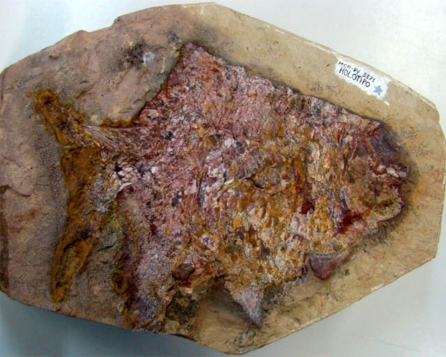
But this doesn’t settle another issue: differences between T. rex specimens themselves. Check out the different skulls – so far, all considered to be of the same species – and see if soon we’ll have Tyrannosaurus X, rex cousin.

“Are you my mommy?” One of the biggest debates in the T. rex family tree is the nature of its offspring. Sure, some youngsters have been found, but there’s this pesky issue ofNanotyrannus. Most scientists believe the Nano is its own, related, slightly smaller species, a pygmy Tyrannosaur with relatively longer legs, a slimmer body, and narrower teeth – but some people have wondered if Nano isn’t really just a young rex. Scientists on both sides of the fence have compared its parts, of which there are only one isolated skull and a recently-discovered skeletonto other fossils identified as “legitimate” T. rex kids. What do you think? Check out the Web site at the Burpee Museum, www.burpee.org, where they’re working on this new skeleton.

Morphoptypes

There are two “morphotypes” of T. rex, called “robust” and “gracile.” Or “beefy” and “wimpy.” Okay, maybe not wimpy, but in this type, nearly every bone is more delicate, and/or shaped a bit differently. What does this mean?In most species – of every kind of creature, not just dinosaurs – these morphotype differences indicate gender. Sometimes these morphotypes have made scientists wonder if they’re looking at two genders of the same creature, or two closely-related species (different creatures altogether). It’s not always easy to tell, but since the morphotypes are so similar, scientists believe we have identified male and female T. rex. Which is which? Check out “Gender” under  Traits.

Skeleton

Has every bone of T. rex been found? How do we know for sure? It would be so much easier if they were walking around now, so we could see every little detail. But they’re not. So we add up everything we have found so far, on all specimens, and we make some conclusions. This is what we know up until, well, yesterday.
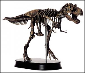
skeleton

skeleton

  • FAQ: Did T. rex stand like a tripod with its tail dragging on the ground, or balanced like a teeter-totter with its tail in mid-air?
  • FAQ: What’s that big upside-down, T-shaped bone hanging down from the pelvis?
  • FAQ: Would every T. rex have exactly the same number of bones?
  • FAQ: How can you tell how the bones fit together?
  • FAQ: Could T. rex have used its tail as a weapon? How can you tell?

Skull

Everyone automatically thinks of T. rex‘s head as its coolest part because it looks so scary. But as the animal’s cockpit, the skull also holds a computer and tons of important information (especially about the senses). T. rex became a little less mysterious when scientists excavated Stan – the specimen with the best skull. It was disarticulated, but that meant we could see inside as never before.
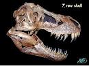
skull

skull

Kinesis, or the ‘Art of Eating Things Bigger than Your Head’, allowed T. rex to eat in a rather indelicate way. Still, it also provided necessary shock absorption – like in birds. Just imagine being a woodpecker, whack, whack, whack – or chomping through someone’s leg bone – without a little “give” in your head.
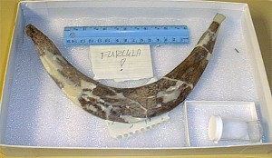
Teeth

The teeth in your mouth have different shapes and functions – sharp ones cut food; flat ones mash it up. T. rex had only one basic shape of tooth: pointy, serrated bananas (although they vary slightly, from rounder to D-shaped to skinnier, and come in different sizes). T. rex had no mashing teeth, which means no chewing! Imagine what that meant for T. rex‘s eating habits: bite, shear, swallow.
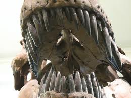
 teeth

teeth

The lower, or dentary, teeth are rounder in cross-section than the upper, or maxillary teeth. All T. rex teeth have two serrated edges for cutting. Most have one in front and one in the back, but the position of the serrations depends on each tooth’s position in the mouth. The serrations follow the shape of the jaw, like a cookie cutter – so T. rex could bite chunks that would fit in its mouth. At the back of the mouth, serrations are at the front and back; by the time you get to the front of the jaw, the serrations are both on the back of the tooth.
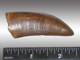
teeth1

teeth1

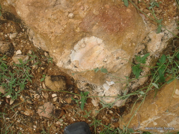
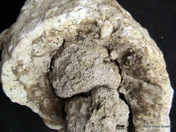
Scientists usually find T. rex teeth in two conditions: shed and rooted. A whole tooth, with its root still attached, looks rather like an entire banana. The presence of rooted teeth at a dig site is excellent evidence that the skull is nearby; the creature died with those teeth in its mouth, and they didn’t fall out until they rotted outShed teeth are basically broken off into the shape of half a banana (top or bottom). Shedding would occur during eating or fighting, and we find shed teeth at excavations of animals that made up T. rex‘s diet.

In T. rex, tooth replacement happened much differently than in the human mouth, which allows for only one set of baby teeth and one set of adult teeth. T. rex kept growing new teeth throughout their lives.
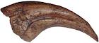
Claws

Manus and Pes. T. rex claws are part of its very important tool kit. The outside, or “nail,” of the claw has not been preserved for T. rex, but we know from other animals (including some dinosaurs) that the actual sheath of the claw extended way beyond the bone. This means that the four-inch bony part of the thumb claw would be covered with a six-inch sheath. Hand, or manus claws, are narrow, strongly curved, and designed as meat hooks to grasp prey. Foot, or pes claws, are broad, weakly curved, and were used for traction, and possibly defense.

claw

claw

Cats are the only living animals that have retractable claws. In extinct animals, we can tell from the fossils whether the claws retracted – most cats’ did and some, like the living cheetah, didn’t. In dinosaurs, only one group had retractable claws, and theirs was the single “killer” claw of the foot. Can you guess which group of creatures this was?
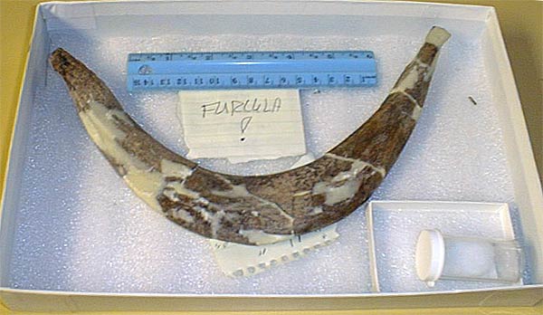
Furcula

furcula

furcula

What do you think of when you say, “wishbone”? Turkey dinners! But what was the function of a wishbone – whose real name is furcula? Scientists recently put a live bird in a wind tunnel and had it fly against the currents – while X-raying it with a fluoroscope, or a moving X-ray machine. The bird’s wishbone acted like a spring, helping the wings with extra oomph. But while pterosaurs flew (without a wishbone!), T. rex certainly did not.

Corpolite

It’s not always easy to talk about coprolites with a straight face. We’ve been taught not to talk about this subject in polite company – but when it’s science, isn’t that DIFFERENT? Of course it is! Coprolites are poop, scat, excrement – you get the picture – and they tell us way more than you can imagine! Poop can tell us who made it, what the creature ate, what its eating habits and digestive system were like, and maybe something more specific about the animal it ate.
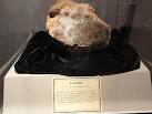
corpolite

corpolite

Believe it or not, we’ve actually found T. rex poop. We know it’s T. rex poop because of its size (no one else who lived at that place, at the time, was big enough to make such a thing) and because it was made by a meat-eating dinosaur (it has pieces of bone inside). Some poop found with Sue had acid-etched duckbill bones mixed in. Because these bones are preserved, we know that it had a short and rapid digestive system. In contrast, bones eaten by a crocodile are completely dissolved within the digestive tract before excretion. This tells us that a T. rex digestive system worked more like a bird’s than a crocodile’s.

False poop! Beware, in your fossil hunting, of rocks disguised as coprolites.

Courtesy: unearthing T .Rex

Why Did Mammals Survive the ‘K/T Extinction’?

Picture a dinosaur. Huge, menacing creatures, they ruled the Earth for nearly 200 million years, striking fear with every ground-shaking stride. Yet these great beasts were no match for a 6-mile wide meteor that struck near modern-day Mexico 65 million years ago, incinerating everything in its path. This catastrophic impact — called the Cretaceous-Tertiary or K/T extinction event — spelled doom for the dinosaurs and many other species. Some animals, however, including many small mammals, managed to survive.

How did they do it?

“They were better at escaping the heat,” said Russ Graham, senior research associate in geosciences at Penn State. “It was the huge amount of thermal heat released by the meteor strike that was the main cause of the K/T extinction.”

K T Extinction boundary

K T Extinction boundary

He said underground burrows and aquatic environments protected small mammals from the brief but drastic rise in temperature. In contrast, the larger dinosaurs would have been completely exposed, and vast numbers would have been instantly burned to death.

K T Extinction boundary

K T Extinction boundary

After several days of searing heat, the earth’s surface temperature returned to bearable levels, and the mammals emerged from their burrows, but it was a barren wasteland they encountered, one that presented yet another set of daunting conditions to be overcome, Graham said. It was their diet which enabled these mammals to survive in habitats nearly devoid of plant life.

“Even if large herbivorous dinosaurs had managed to survive the initial meteor strike, they would have had nothing to eat,” he said, “because most of the earth’s above-ground plant material had been destroyed.”

Mammals, in contrast, could eat insects and aquatic plants, which were relatively abundant after the meteor strike. As the remaining dinosaurs died off, mammals began to flourish. Although representatives from other classes of animals also survived the K/T extinction — crocodiles, for instance, had the saving ability to take to water — mammals were clearly the main beneficiaries and they have since spread to nearly every corner of the planet.