WFS News: Scientists reveals an event of active ‘drip’ tectonics

@WFS,World Fossil Society,Riffin T Sajeev,Russel T Sajeev

When renowned University of Toronto (U of T) geophysicist J. Tuzo Wilson cemented concepts in the emerging field of plate tectonics in the 1960s, he revolutionized the study of Earth’s physical characteristics and behaviours. Decades later, successor researchers at U of T and Istanbul Technical University have determined that a series of volcanoes and a mountain plateau across central Turkey formed not solely by the collision of tectonic plates, but instead by a massive drip and then detachment of the lower tectonic plate beneath Earth’s surface.

The researchers propose that the reason the Central Anatolian (Turkish) Plateau has risen by as much as one kilometre over the past 10 million years is because the planet’s crust and upper mantle — the lithosphere — has thickened and dripped below the region. As the lithosphere sank into the lower mantle, it first formed a basin at the surface, which later sprang up when the weight below broke off and sank further into the deeper depths of the mantle.

Cave city in volcanic rocks of uplifted Central Anatolian plateau. Credit: Russell Pysklywec

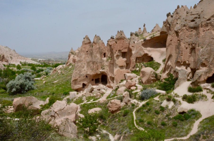
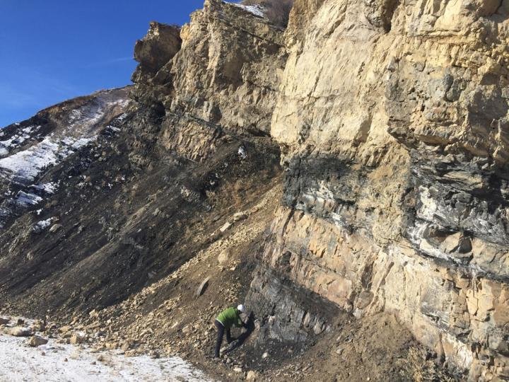
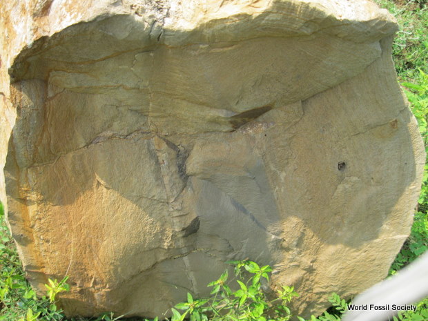
Cave city in volcanic rocks of uplifted Central Anatolian plateau.Credit: Russell Pysklywec

“It seems the heavy base of the tectonic plate has ‘dripped’ off into the mantle, leaving a massive gap in the plate beneath Central Anatolia. Essentially, by dropping this dense lithospheric anchor, there has been an upward bobbing of the entire land mass across hundreds of kilometres,” said Professor Oğuz H. Göğüş of the Eurasia Institute of Earth Sciences at Istanbul Technical University (ITU), lead author of a study reporting the findings published in Nature Communications this month.

It’s a new idea where plate shortening initially squeezed and folded a mountain belt, triggering the thickening and dripping of the deep lithosphere, and then increasing the elevation of most of central Turkey. Puzzled by the presence of such a process at a significant distance away from regular plate tectonic boundaries, the research team set about identifying why, in an area of high heating and high elevation, is the lithosphere below completely gone — something that was recently discovered from seismology.

They tested high-performance computational models against known geological and geophysical observations of the Central Anatolian Plateau, and demonstrated that a drip of lithospheric material below the surface can account for the measured elevation changes across the region.

“It’s a new variation on the fundamental concepts of plate tectonics,” said Professor Russell Pysklywec, chair of the Department of Earth Sciences at U of T and one of the study’s coauthors. “It gives us some insight into the connection between the slow circulation of near-solid rock in Earth’s mantle caused by convection currents carrying heat upwards from the planet’s interior, and observed active plate tectonics at the surface.

“This is part of the holy grail of plate tectonics — linking the two processes to understand how the crust responds to the mantle thermal engine of the planet.”

Pysklywec carried out the study with Göğüş, who received his PhD from U of T in 2010, and fellow researchers at ITU including Professor A. M. C. Şengör, and Erkan Gün of the Eurasia Institute of Earth Sciences at Istanbul Technical Institute. Gün is also now a current graduate student at U of T, supervised by Pysklywec. The research adds to decades of groundbreaking work in plate tectonics at U of T, and builds on Wilson’s seminal work.

“Tuzo Wilson is a towering figure in geophysics internationally and the person most responsible for pioneering the ideas of plate tectonics in the 1960s,” said Pysklywec. “I am pleased that we are continuing his legacy in geophysics with our work.”

While Pysklywec notes there are many locations on Earth missing its lithosphere below, he is quick to reassure that no place is in imminent danger of sinking into the mantle or boosting upwards overnight. “Our results show that the Central Anatolian Plateau rose over a period of millions of years. We’re talking about mantle fluid motions and uplift at the pace at which fingernails grow.”

Göğüş highlights the links of the tectonics with human history saying, “The findings are exciting also because of the link with the remarkable historical human activity of Central Anatolia where some of the earliest known civilizations have existed. For example, Central Anatolia is described as an elevated, dry, cold plain of Lycaonia in Strabo’s Geographika in 7 BC, and even cave paintings in the region dating to approximately 7000 BC record active volcanic eruptions on the plateau.”

  1. Oğuz H. Göğüş, Russell N. Pysklywec, A. M. C. Şengör, Erkan Gün. Drip tectonics and the enigmatic uplift of the Central Anatolian Plateau. Nature Communications, 2017; 8 (1) DOI: 10.1038/s41467-017-01611-3
University of Toronto. “Geophysicists uncover new evidence for an alternative style of plate tectonics: Canadian-Turkish collaboration reveals an event of active ‘drip’ tectonics.” ScienceDaily. ScienceDaily, 28 November 2017. <www.sciencedaily.com/releases/2017/11/171128135641.htm>.
@WFS,World Fossil Society,Riffin T Sajeev,Russel T Sajeev

WFS News: Feathered dinosaurs were even fluffier than we thought

@WFS,World Fossil Society,Riffin T Sajeev,Russel T Sajeev

A University of Bristol-led study has revealed new details about dinosaur feathers and enabled scientists to further refine what is potentially the most accurate depiction of any dinosaur species to date.

Birds are the direct descendants of a group of feathered, carnivorous dinosaurs that, along with true birds, are referred to as paravians — examples of which include the infamous Velociraptor.

Researchers examined, at high resolution, an exceptionally-preserved fossil of the crow-sized paravian dinosaur Anchiornis — comparing its fossilised feathers to those of other dinosaurs and extinct birds.

The feathers around the body of Anchiornis, known as contour feathers, revealed a newly-described, extinct, primitive feather form consisting of a short quill with long, independent, flexible barbs erupting from the quill at low angles to form two vanes and a forked feather shape.

Depiction of Anchiornis and its contour feather. Credit: Rebecca Gelernter

Depiction of Anchiornis and its contour feather.Credit: Rebecca Gelernter

The observations were made possible by decay processes that separated some of these feathers from the body prior to burial and fossilisation, making their structure easier to interpret.

Such feathers would have given Anchiornis a fluffy appearance relative to the streamlined bodies of modern flying birds, whose feathers have tightly-zipped vanes forming continuous surfaces. Anchiornis‘s unzipped feathers might have affected the animal’s ability to control its temperature and repel water, possibly being less effective than the vanes of most modern feathers. This shaggy plumage would also have increased drag when Anchiornis glided.

Additionally, the feathers on the wing of Anchiornis lack the aerodynamic, asymmetrical vanes of modern flight feathers, and the new research shows that these vanes were also not tightly-zipped compared to modern flight feathers. This would have hindered the feather’s ability to form a lift surface. To compensate, paravians like Anchiornis packed multiple rows of long feathers into the wing, unlike modern birds, where most of the wing surface is formed by just one row of feathers.

Furthermore, Anchiornis and other paravians had four wings, with long feathers on the legs in addition to the arms, as well as elongated feathers forming a fringe around the tail. This increase in surface-area likely allowed for gliding before the evolution of powered flight.

To assist in reconstructing the updated look of Anchiornis, scientific illustrator Rebecca Gelernter worked with Evan Saitta and Dr Jakob Vinther, from the University of Bristol’s School of Earth Sciences and School of Biological Sciences, to draw the animal as it was in life.

The new piece represents a radical shift in dinosaur depictions and incorporates previous research.

The color patterns for Anchiornis are known from fossilised pigment studies, the outline of the flesh of the animal has been constructed by examining fossils under laser fluorescence, and previous work has described the multi-tiered layering of the wing feathers.

Evan Saitta said: “The novel aspects of the wing and contour feathers, as well as fully-feathered hands and feet, are added to the depiction.

“Most provocatively, Anchiornis is presented in this artwork climbing in the manner of hoatzin chicks, the only living bird whose juveniles retain a relic of their dinosaurian past, a functional claw.

“This contrasts much previous art that places paravians perched on top of branches like modern birds.

“However, such perching is unlikely given the lack of a reversed toe as in modern perching birds and climbing is consistent with the well-developed arms and claws in paravians.

“Overall, our study provides some new insight into the appearance of dinosaurs, their behavior and physiology, and the evolution of feathers, birds, and powered flight.”

Rebecca Gelernter added: “Paleoart is a weird blend of strict anatomical drawing, wildlife art, and speculative biology. The goal is to depict extinct animals and plants as accurately as possible given the available data and knowledge of the subject’s closest living relatives.

“As a result of this study and other recent work, this is now possible to an unprecedented degree for Anchiornis. It’s easy to see it as a living animal with complex behaviours, not just a flattened fossil.

“It’s really exciting to be able to work with the scientists at the forefront of these discoveries, and to show others what we believe these fluffy, toothy almost-birds looked like as they went about their Jurassic business.”

  1. E. Saitta, R. Gelernter and J. Vinther. Additional information on the primitive contour and wing feathering of paravian dinosaurs. Paleontology, 2017
University of Bristol. “Feathered dinosaurs were even fluffier than we thought.” ScienceDaily. ScienceDaily, 28 November 2017. <www.sciencedaily.com/releases/2017/11/171128230425.htm>.
@WFS,World Fossil Society,Riffin T Sajeev,Russel T Sajeev

WFS News: Ancient flying reptiles cared for their young, fossil trove suggests

@WFS,World Fossil Society,Riffin T Sajeev,Russel T Sajeev

A spectacular fossil find is providing tantalizing new clues about the habits of pterosaurs, ancient flying reptiles that lived at the same times as dinosaurs. The cache of more than 200 fossil eggs found with bones of juvenile and adult animals in northwestern China is “one of the most extraordinary fossil [finds] I’ve ever seen,” says David Unwin, a paleontologist at the University of Leicester in the United Kingdom, who was not involved in the work. And it suggests to some researchers that pterosaur parents may have cared for their newly hatched young.

Pterosaur parents may have cared for their young.

Pterosaur parents may have cared for their young.

The fossils formed about 120 million years ago when disaster struck a group of pterosaurs. The researchers speculate that when a sudden rain flooded a river, hundreds of pterosaur eggs buried in shallow sand or under a layer of leaves or grass were drowned and washed downstream, along with a number of older individuals. Quickly buried by sediment, the eggs and bones did not decay but instead were preserved as fossils. “You’ve captured the life history of pterosaurs,” Unwin says.

Only a few fossilized pterosaur eggs had turned up before, at sites in Argentina and in China. But in a paper published today in Science, Wang Xiaolin and Jiang Shunxing at the Chinese Academy of Sciences’s Institute of Vertebrate Paleontology and Paleoanthropology in Beijing and their colleagues report that a 3-meter square chunk of rock they excavated in the Turpan-Hami Basin in northwest China contains more than 200 eggs of the pterosaur, called Hamipterus tianshanensis. In 16 of them, researchers have been able to identify fossilized bones of developing embryos. Whatever transported the eggs to their resting place likely damaged them, so the bones are jumbled and incomplete. But enough is preserved to allow comparisons between the bones in the embryos and those of older pterosaurs also preserved, says Alexander Kellner of the National Museum at the Federal University of Rio de Janeiro in Brazil, who helped analyze the fossils. “It’s amazing,” he says. “We never thought we would find so many eggs.”

The researchers used computerized tomography scans to measure some of the embryonic bones and took thin slices of some to tell how mature they were. In one particularly well preserved egg, the hind limbs were more developed than the forelimbs. That suggests, Kellner says, that pterosaurs could walk when they hatched, but not fly. The embryos also appeared to be toothless, unlike some dinosaur embryos. Together, the authors say, the evidence suggests that hatchlings might have not been able to hunt for themselves, relying on their parents to feed them. “They needed some sort of parental care,” Kellner says.

This Chinese fossil contains hundreds of pterosaur eggs and bones.

This Chinese fossil contains hundreds of pterosaur eggs and bones.

Unwin says he’s not yet convinced. The smallest hatchlings in the sample are 40% bigger than the embryos, he notes, so the forelimbs might have matured by the time they hatched. Charles Deeming, an expert on reptile reproduction at the University of Lincoln in the United Kingdom, also cautions about drawing firm conclusions from close analysis of just a few eggs. Although fossil egg finds are spectacular, he says, “one of the dangers … is that they are often overinterpreted.”

Jiang says that’s a fair critique, but he and others say further analysis of the wealth of eggs at the site will eventually provide firmer evidence one way or another. “The numbers [of eggs and bones] mean that we can move on from positing ideas to testing ideas,” Unwin says. Pterosaur remains scattered through multiple layers of the rocks suggest that the site was a pterosaur nesting site for many years. “It must have been a great place to bury eggs,” Unwin says—until, periodically, catastrophe struck. The specimen described today is only the start, Jiang says. “There are many more eggs.”

Source: Report by Gretchen Vogel,sciencemag.org

@WFS,World Fossil Society,Riffin T Sajeev,Russel T Sajeev

WFS News: Biomass recycling and Earth’s early phosphorus cycle

@WFS,World Fossil Society,Riffin T Sajeev,Russel T Sajeev

The amount of biomass — life — in Earth’s ancient oceans may have been limited due to low recycling of the key nutrient phosphorus, according to new research by the University of Washington and the University of St. Andrews in Scotland.

The research, published online Nov. 22 in the journal Science Advances, also comments on the role of volcanism in supporting Earth’s early biosphere — and may even apply to the search for life on other worlds.

The paper’s lead author is Michael Kipp, a UW doctoral student in Earth and space sciences; coauthor is Eva Stüeken, a research fellow at the University of St. Andrews and former UW postdoctoral researcher. Roger Buick, UW professor of Earth and space sciences, advised the researchers.

As Earth's oxygen levels rose to near-modern levels over the last 800 million years, phosphorus levels increased, as well, according to modeling led by the UW's Michael Kipp and others. Accordingly, Kipp says, large phosphate deposits show up in abundance in the rock record at about this time. This is a Wyoming portion of The Phosphoria Formation, a deposit that stretches across several states in the western United States and is the largest source of phosphorus fertilizer in the country. The photo shows layers of phosphorus that are 10s of meters thick, shales the contain high concentrations of organic carbon and phosphorus. Kipp said many such deposits are documented over time but are rare in the Precambrian era. "Thus, they might represent a conspicuous temporal record of limited phosphorus recycling." Credit: Michael Kipp / University of Washington

As Earth’s oxygen levels rose to near-modern levels over the last 800 million years, phosphorus levels increased, as well, according to modeling led by the UW’s Michael Kipp and others. Accordingly, Kipp says, large phosphate deposits show up in abundance in the rock record at about this time. This is a Wyoming portion of The Phosphoria Formation, a deposit that stretches across several states in the western United States and is the largest source of phosphorus fertilizer in the country. The photo shows layers of phosphorus that are 10s of meters thick, shales the contain high concentrations of organic carbon and phosphorus. Kipp said many such deposits are documented over time but are rare in the Precambrian era. “Thus, they might represent a conspicuous temporal record of limited phosphorus recycling.”Credit: Michael Kipp / University of Washington

Their aim, Kipp said, was to use theoretical modeling to study how ocean phosphorus levels have changed throughout Earth’s history.

“We were interested in phosphorus because it is thought to be the nutrient that limits the amount of life there is in the ocean, along with carbon and nitrogen,” said Kipp. “You change the relative amount of those and you change, basically, the amount of biological productivity.”

Kipp said their model shows the ability of phosphorus to be recycled in the ancient ocean “was much lower than today, maybe on the order of 10 times less.”

All life needs abundant food to thrive, and the chemical element phosphorus — which washes into the ocean from rivers as phosphate — is a key nutrient. Once in the ocean, phosphorus gets recycled several times as organisms such as plankton or eukaryotic algae that “eat” it are in turn consumed by other organisms.

“As these organisms use the phosphorus, they in turn get grazed upon, or they die and other bacteria decompose their organic matter,” said Kipp, “and they release some of that phosphorus back into the ocean. It actually cycles through several times,” allowing the liberated phosphorus to build up in the ocean. The amount of recycling is a key control on the amount of total phosphorus in the ocean, which in turn supports life.

Buick explained: “Every gardener knows that their plants grow only small and scraggly without phosphate fertilizer. The same applies for photosynthetic life in the oceans, where the phosphate ‘fertilizer’ comes largely from phosphorus liberated by the degradation of dead plankton.”

But all of this requires oxygen. In today’s oxygen-rich oceans, nearly all phosphorus gets recycled in this way and little falls to the ocean floor. Several billion years ago, in the Precambrian era, however, there was little or no oxygen in the environment.

“There are some alternatives to oxygen that certain bacteria could use, said co-author Stüeken. “Some bacteria can digest food using sulfate. Others use iron oxides.” Sulfate, she said, was the most important control on phosphorus recycling in the Precambrian era.

“Our analysis shows that these alternative pathways were the dominant route of phosphorus recycling in the Precambrian, when oxygen was very low,” Stüeken said. “However, they are much less effective than digestion with oxygen, meaning that only a smaller amount of biomass could be digested. As a consequence, much less phosphorus would have been recycled, and therefore total biological productivity would have been suppressed relative to today.”

Kipp likened early Earth’s low-oxygen ocean to a kind of “canned” environment, with oxygen sealed out: “It’s a closed system. If you go back to the early Precambrian oceans, there’s not very much going on in terms of biological activity.”

Stüeken noted that volcanoes were the biggest source of sulfate in the Precambrian, unlike now, and so they were necessary for sustaining a significant biosphere by enabling phosphorus recycling.

In fact, minus such volcanic sulfate, Stüeken said, Earth’s biosphere would have been very small, and may not have survived over billions of years. The findings, then, illustrate “how strongly life is tied to fundamental geological processes such as volcanism on the early Earth,” she said.

Kipp and Stüeken’s modeling may have implications as well for the search for life beyond Earth.

Astronomers will use upcoming ground- and space-based telescopes such as the James Webb Space Telescope, set for launch in 2019, to look for the impact of a marine biosphere, as Earth has, on a planet’s atmosphere. But low phosphorus, the researchers say, could cause an inhabited world to appear uninhabited — making a sort of “false negative.”

Kipp said, “If there is less life — basically, less photosynthetic output — it’s harder to accumulate atmospheric oxygen than if you had modern phosphorus levels and production rates. This could mean that some planets might appear to be uninhabited due to their lack of oxygen, but in reality they have biospheres that are limited in extent due to low phosphorus availability.

“These ‘false negatives’ are one of the biggest challenges facing us in the search for life elsewhere,” said Victoria Meadows, UW astronomy professor and principal investigator for the NASA Astrobiology Institute’s Virtual Planetary Laboratory, based at the UW.

“But research on early Earth’s environments increases our chance of success by revealing processes and planetary properties that guide our search for life on nearby exoplanets.”

  1. Michael A. Kipp, Eva E. Stüeken. Biomass recycling and Earth’s early phosphorus cycle. Science Advances, 2017; 3 (11): eaao4795 DOI: 10.1126/sciadv.aao4795
University of Washington. “Less life: Limited phosphorus recycling suppressed early Earth’s biosphere.” ScienceDaily. ScienceDaily, 27 November 2017. <www.sciencedaily.com/releases/2017/11/171127152032.htm>.
@WFS,World Fossil Society,Riffin T Sajeev,Russel T Sajeev

WFS News: Matheronodon provincialis ,New Herbivorous Dinosaur Species

@WFS,World Fossil Society,Riffin T Sajeev,Russel T Sajeev

Matheronodon provincialis was a primitive cousin of the well-known European dinosaur Iguanodon.

Artist’s impression of Matheronodon provincialis. Image credit: Lukas Panzarin.

Artist’s impression of Matheronodon provincialis. Image credit: Lukas Panzarin.

The ancient beast lived 70 million years ago (Late Cretaceous epoch) and was approximately 16 feet (5 m) long.

The fossilized jawbone and three teeth of the new species were discovered at the site of Velaux-La Bastide Neuve, Bouches-du-Rhône Department, southern France.

Matheronodon provincialis had extremely enlarged teeth, up to 2.4 inches (6 cm) long and 2 inches (5 cm) wide. They operated like self-sharpening serrated scissors,” said Dr. Koen Stein, a paleontologist at Free University of Brussels, Belgium.

“Its teeth have ridged surfaces but are only covered with a thick enamel layer on one side.”

“Because the enamel is more resistant to wear than the exposed dentine, chewing actually keeps the teeth sharp.”

The fossilized jawbone of Matheronodon provincialis. Image credit: Godefroit et al, doi: 10.1038/s41598-017-13160-2.

The fossilized jawbone of Matheronodon provincialis. Image credit: Godefroit et al, doi: 10.1038/s41598-017-13160-2.

“The denture of rhabdodontid dinosaurs (Rhabdodontidae) had evolved in a different direction than that of their contemporaries, the hadrosaurs or duck-billed dinosaurs,” said Dr. Pascal Godefroit, a paleontologist at the Royal Belgian Institute of Natural Sciences.

“Hadrosaurs had sophisticated dental ‘batteries’ formed by little teeth with which they could crush conifers.”

Matheronodon provincialis and other Rhabdodontidae probably ate leaves of palm trees, which were abundant in Europe at that time.”

“They had to cut rather than crush the fiber-rich leaves, before they could swallow them.”

Source: Pascal Godefroit et al. 2017. Extreme tooth enlargement in a new Late Cretaceous rhabdodontid dinosaur from Southern France. Scientific Reports 7, article number: 13098; doi: 10.1038/s41598-017-13160-2 Published in Sci News.

@WFS,World Fossil Society,Riffin T Sajeev,Russel T Sajeev

WFS News: Climate change could increase volcano eruptions

@WFS,World Fossil Society,Riffin T Sajeev,Russel T Sajeev

Shrinking glacier cover could lead to increased volcanic activity in Iceland, warn scientists.

A new study, led by the University of Leeds, has found that there was less volcanic activity in Iceland when glacier cover was more extensive and as the glaciers melted volcanic eruptions increased due to subsequent changes in surface pressure.

Dr Graeme Swindles, from the School of Geography at Leeds, said: “Climate change caused by humans is creating rapid ice melt in volcanically active regions. In Iceland, this has put us on a path to more frequent volcanic eruptions.”

The study examined Icelandic volcanic ash preserved in peat deposits and lake sediments and identified a period of significantly reduced volcanic activity between 5,500 and 4,500 years ago. This period came after a major decrease in global temperature, which caused glacier growth in Iceland.

Tephras -- rock fragments and particles ejected by a volcanic eruption. Credit: Image courtesy of University of Leeds

Tephras — rock fragments and particles ejected by a volcanic eruption.   Credit: Image courtesy of University of Leeds

The findings, published in the journal Geology, found there was a time lag of roughly 600 years between the climate event and a noticeable decrease in the number of volcanic eruptions. The study suggests that perhaps a similar time lag can be expected following the more recent shift to warmer temperatures.

Iceland’s volcanic system is in process of recovering from the ‘Little Ice Age’ — a recorded period of colder climate roughly between the years 1500 to 1850. Since the end of the Little Ice Age, a combination of natural and human caused climate warming is causing Icelandic glaciers to melt again.

Dr Swindles said: “The human effect on global warming makes it difficult to predict how long the time lag will be but the trends of the past show us more eruptions in Iceland can be expected in the future.

“These long term consequences of human effect on the climate is why summits like COP are so important. It is vital to understand how actions today can impact future generations in ways that have not been fully realised, such as more ash clouds over Europe, more particles in the atmosphere and problems for aviation. ”

Icelandic volcanism is controlled by complex interactions between rifts in continental plate boundaries, underground gas and magma build-up and pressure on the volcano’s surface from glaciers and ice. Changes in surface pressure can alter the stress on shallow chambers where magma builds up.

Study co-author, Dr Ivan Savov, from the School of Earth & Environment at Leeds, explains: “When glaciers retreat there is less pressure on Earth’s surface. This can increase the amount of mantle melt as well as affect magma flow and how much magma the crust can hold.

“Even small changes in surface pressure can alter the likelihood of eruptions at ice-covered volcanos.”

  1. Graeme T. Swindles, Elizabeth J. Watson, Ivan P. Savov, Ian T. Lawson, Anja Schmidt, Andrew Hooper, Claire L. Cooper, Charles B. Connor, Manuel Gloor, Jonathan L. Carrivick. Climatic control on Icelandic volcanic activity during the mid-Holocene. Geology, 2017; DOI: 10.1130/G39633.1
University of Leeds. “Climate change could increase volcano eruptions.” ScienceDaily. ScienceDaily, 23 November 2017. <www.sciencedaily.com/releases/2017/11/171123095405.htm>.
@WFS,World Fossil Society,Riffin T Sajeev,Russel T Sajeev

WFS News: Mysterious deep-Earth seismic signature explained

@WFS,World Fossil Society,Riffin T Sajeev,Russel T Sajeev

New research on oxygen and iron chemistry under the extreme conditions found deep inside Earth could explain a longstanding seismic mystery called ultralow velocity zones. Published in Nature, the findings could have far-reaching implications on our understanding of Earth’s geologic history, including life-altering events such as the Great Oxygenation Event, which occurred 2.4 billion years ago.

Sitting at the boundary between the lower mantle and the core, 1,800 miles beneath Earth’s surface, ultralow velocity zones (UVZ) are known to scientists because of their unusual seismic signatures. Although this region is far too deep for researchers to ever observe directly, instruments that can measure the propagation of seismic waves caused by earthquakes allow them to visualize changes in Earth’s interior structure; similar to how ultrasound measurements let medical professionals look inside of our bodies.

The movement of seismic waves through the material of the mantle allows scientists to image Earth's interior, just as a medical ultrasound allows technicians to look inside a blood vessel. Image is courtesy of Edward Garnero and Allen McNamara's 2008 Science paper Structure and Dynamics of Earth's Lower Mantle, provided with Garnero's permission. Credit: Edward Garnero and Allen McNamara

The movement of seismic waves through the material of the mantle allows scientists to image Earth’s interior, just as a medical ultrasound allows technicians to look inside a blood vessel. Image is courtesy of Edward Garnero and Allen McNamara’s 2008 Science paper Structure and Dynamics of Earth’s Lower Mantle, provided with Garnero’s permission.
Credit: Edward Garnero and Allen McNamara

These seismic measurements enabled scientists to visualize these ultralow velocity zones in some regions along the core-mantle boundary, by observing the slowing down of seismic waves passing through them. But knowing UVZs exist didn’t explain what caused them.

However, recent findings about iron and oxygen chemistry under deep-Earth conditions provide an answer to this longstanding mystery.

It turns out that water contained in some minerals that get pulled down into Earth due to plate tectonic activity could, under extreme pressures and temperatures, split up — liberating hydrogen and enabling the residual oxygen to combine with iron metal from the core to create a novel high-pressure mineral, iron peroxide.

Led by Carnegie’s Ho-kwang “Dave” Mao, the research team believes that as much as 300 million tons of water could be carried down into Earth’s interior every year and generate deep, massive reservoirs of iron dioxide, which could be the source of the ultralow velocity zones that slow down seismic waves at the core-mantle boundary.

To test this idea, the team used sophisticated tools at Argonne National Laboratory to examine the propagation of seismic waves through samples of iron peroxide that were created under deep-Earth-mimicking pressure and temperature conditions employing a laser-heated diamond anvil cell. They found that a mixture of normal mantle rock with 40 to 50 percent iron peroxide had the same seismic signature as the enigmatic ultralow velocity zones.

For the research team, one of the most-exciting aspects of this finding is the potential of a reservoir of oxygen deep in the planet’s interior, which if periodically released to Earth’s surface could significantly alter Earth’s early atmosphere, potentially explaining the dramatic increase in atmospheric oxygen that occurred about 2.4 billion years ago according to the geologic record.

“Finding the existence of a giant internal oxygen reservoir has many far-reaching implications,” Mao explained. “Now we should reconsider the consequences of sporadic oxygen outbursts and their correlations to other major events in Earth’s history, such as the banded-iron formation, snowball Earth, mass extinctions, flood basalts, and supercontinent rifts.”

  1. Jin Liu, Qingyang Hu, Duck Young Kim, Zhongqing Wu, Wenzhong Wang, Yuming Xiao, Paul Chow, Yue Meng, Vitali B. Prakapenka, Ho-Kwang Mao, Wendy L. Mao. Hydrogen-bearing iron peroxide and the origin of ultralow-velocity zones. Nature, 2017; 551 (7681): 494 DOI: 10.1038/nature24461
Carnegie Institution for Science. “Mysterious deep-Earth seismic signature explained: Finding has implications for conditions that set the stage for life.” ScienceDaily. ScienceDaily, 22 November 2017. <www.sciencedaily.com/releases/2017/11/171122131429.htm>.
@WFS,World Fossil Society,Riffin T Sajeev,Russel T Sajeev

WFS News: How Earth stops high-energy neutrinos in their tracks

@WFS,World Fossil Society,Riffin T Sajeev,Russel T Sajeev

For the first time, a science experiment has measured Earth’s ability to absorb neutrinos — the smaller-than-an-atom particles that zoom throughout space and through us by the trillions every second at nearly the speed of light. The experiment was achieved with the IceCube detector, an array of 5,160 basketball-sized sensors frozen deep within a cubic kilometer of very clear ice near the South Pole. The results of this experiment by the IceCube collaboration, which includes Penn State physicists, will be published in the online edition of the journal Nature on November 22, 2017.

This image shows a visual representation of one of the highest-energy neutrino detections superimposed on a view of the IceCube Lab at the South Pole. Credit: IceCube Collaboration

This image shows a visual representation of one of the highest-energy neutrino detections superimposed on a view of the IceCube Lab at the South Pole.Credit: IceCube Collaboration

“This achievement is important because it shows, for the first time, that very-high-energy neutrinos can be absorbed by something — in this case, the Earth,” said Doug Cowen, professor of physics and astronomy & astrophysics at Penn State. The first detections of extremely-high-energy neutrinos were made by IceCube in 2013, but a mystery remained about whether any kind of matter could truly stop a neutrino’s journey through space. “We knew that lower-energy neutrinos pass through just about anything,” Cowen said, “but although we had expected higher-energy neutrinos to be different, no previous experiments had been able to demonstrate convincingly that higher-energy neutrinos could be stopped by anything.”

The results in the Nature paper are based on one year of data from about 10,800 neutrino-related interactions. Cowen and Tyler Anderson, an assistant research professor of physics at Penn State, are members of the IceCube collaboration. They are coauthors of the Nature paper who helped to build the IceCube detector and are contributing to its maintenance and management.

This new discovery with IceCube is an exciting addition to our deepening understanding of how the universe works. It also is a little bit of a disappointment for those who hope for an experiment that will reveal something that cannot be explained by the current Standard Model of Particle Physics. “The results of this Ice Cube study are fully consistent with the Standard Model of Particle Physics — the reigning theory that for the past half century has described all the physical forces in the universe except gravity,” Cowen said.

Neutrinos first were formed at the beginning of the universe, and they continue to be produced by stars throughout space and by nuclear reactors on Earth. “Understanding how neutrinos interact is key to the operation of IceCube,” explained Francis Halzen, principal investigator for the IceCube Neutrino Observatory and a University of Wisconsin-Madison professor of physics. “We were of course hoping for some new physics to appear, but we unfortunately find that the Standard Model, as usual, withstands the test,” Halzen said.

IceCube’s sensors do not directly observe neutrinos, but instead measure flashes of blue light, known as Cherenkov radiation, emitted after a series of interactions involving fast-moving charged particles that are created when neutrinos interact with the ice. By measuring the light patterns from these interactions in or near the detector array, IceCube can estimate the neutrinos’ energies and directions of travel. The scientists found that the neutrinos that had to travel the farthest through Earth were less likely to reach the detector.

Most of the neutrinos selected for this study were more than a million times more energetic than the neutrinos produced by more familiar sources, like the Sun or nuclear power plants. The analysis also included a small number of astrophysical neutrinos, which are produced outside the Earth’s atmosphere, from cosmic accelerators unidentified to date, perhaps associated with supermassive black holes.

“Neutrinos have quite a well-earned reputation of surprising us with their behavior,” says Darren Grant, spokesperson for the IceCube Collaboration, a professor of physics at the University of Alberta in Canada, and a former postdoctoral scholar at Penn State. “It is incredibly exciting to see this first measurement and the potential it holds for future precision tests.”

In addition to providing the first measurement of the Earth’s absorption of neutrinos, the analysis shows that IceCube’s scientific reach extends beyond its core focus on particle physics discoveries and the emerging field of neutrino astronomy into the fields of planetary science and nuclear physics. This analysis also is of interest to geophysicists who would like to use neutrinos to image the Earth’s interior in order to explore the boundary between the Earth’s inner solid core and its liquid outer core.

“IceCube was built to both explore the frontiers of physics and, in doing so, possibly challenge existing perceptions of the nature of universe. This new finding and others yet to come are in that spirt of scientific discovery,” said James Whitmore, program director in the National Science Foundation’s physics division. Physicists now hope to repeat the study using an expanded, multiyear analysis of data from the full 86-string IceCube array, and to look at higher ranges of neutrino energies for any hints of new physics beyond the Standard Model.

  1. M. G. Aartsen et al. Measurement of the multi-TeV neutrino interaction cross-section with IceCube using Earth absorption. Nature, 2017; DOI: 10.1038/nature24459
Penn State. “How Earth stops high-energy neutrinos in their tracks.” ScienceDaily. ScienceDaily, 22 November 2017. <www.sciencedaily.com/releases/2017/11/171122131359.htm>.
@WFS,World Fossil Society,Riffin T Sajeev,Russel T Sajeev

WFS News: Why did the Earth’s ancient oceans disappear?

@WFS,World Fossil Society,Riffin T Sajeev,Russel T Sajeev

We think of oceans as being stable and permanent. However, they move at about the same speed as your fingernails grow. Geoscientists at CEED, University of Oslo have found a novel way of mapping the Earth’s ancient oceans.

The surface of the Earth is in constant motion. New crust is formed at mid-oceanic ridges, such as the Mid-Atlantic Ridge, and older crust is destroyed.

The maps are showing different viewing options for the region under Southeast Asia. Credit: Illustration Grace E. Shephard

The maps are showing different viewing options for the region under Southeast Asia.
Credit: Illustration Grace E. Shephard

If we go millions of years back in time, the oceans and the continents of planet Earth were very different. Oceans that once existed are now buried deep inside the interior of the Earth, in the mantle.

Seismic tomography uses earthquakes to image Earth’s interior down to approximately 2,800 km. Models based on this technique are used to show how the surface of our planet may have looked like up to 200 million years ago.

Simple and powerful

Grace Shephard at the Centre for Earth Evolution and Dynamics (CEED), University of Oslo has found a simple, yet powerful way to combine images from alternative seismic tomography models. In a new study published in Nature, Shephard and colleagues Mathew Domeier (CEED), Kara Matthews, and Kasra Hosseini (both University of Oxford) reveal a new way of displaying models of the evolution of the Earth’s interior.

“There are many different ways of creating such models, and lots of different data input can be used,” explains Grace Shephard, who has been a postdoctoral researcher at CEED since she took her Ph.D. at the University of Sydney four years ago.

“We wanted a quick and simple way to see which features are common across all of the models. By comparing up to 14 different models, for instance, we can visualize where they agree and thus identify what we call the most robust anomalies. This gives more accurate and more easily available information about the movements of ocean basins and contents back in time — and the interaction between the Earth’s crust and the mantle.”

Reconstructing continents and oceans

The tomography models are used to reconstruct movements of continents and oceans. The novel and open way of displaying the models takes away some of the decision making for scientists studying the dynamics of the Earth.

“With this tool, geoscientists can choose which models to use, how deep into the mantle to go, and a few other parameters,” explains Shephard. — Thus, they can zoom into their area of interest. However, we must remember that the maps are only as good as the tomography models they are built upon.

Grace Shephard and colleagues have also studied if there are more agreement between the various tomography models at certain depths of the mantle. They have made discoveries that suggest more paleoseafloor can be found at around 1,000 — 1,400 km beneath the surface than at other depths.

An inner “traffic jam”?

“If these depths are translated to time — and we presuppose that the seafloor sinks into the mantle at a rate of 1 centimeter per year — it could mean that there was a period around 100-140 million years ago that experienced more ocean destruction. However, it could also identify a controversial region in the Earth that is more viscous, or ‘sticky,’ and causes sinking features to pile up, a bit like a traffic jam. These findings, and the reasons behind, bear critical information about the surface and interior evolution of our planet,” explains Shephard.

To understand the evolution of the Earth, it is essential to study the subduction zones. The tectonic plates of the oceans are being subducted under the continental plates, or under other oceanic plates. Examples include the Pacific Ocean moving under Japan, and subductions within the Mediterranean region. Plate reconstruction models generally agree that about 130 million years ago, there was a peak in the amount of subduction happening. So the maps by Shephard and colleagues could provide independent evidence for this event.

Reversing the evolution Grace Shephard shows us computer animations reversing these evolutionary processes. She brings back to the surface oceans that have been buried deep inside the mantle for millions of years. It may look like a game, but it illustrates an important point:

“Studying these processes in new ways opens up new questions. That is something we welcome, because we need to find out what questions to ask and what to focus on in order to understand the development of the Earth. We always have to keep in mind what is an observations and what is a model. The models need to be tested against observations, to make way for new and improved models. It is an iterative procedure.”

Why are the models of the Earth’s interior important?

“It is a fundamental way of understanding more about our planet, the configuration of continents and oceans, climate change, mountain building, the location of precious resources, biology, etc. Lines of evidence in the past can be crucial for insight into what will happen in the future, and is critical for the interaction of society and the natural environment.”

Earth 1 million years from now

“If you look at Earth from space, the distribution of continents and oceans will then look much the same, even though life, the climate and sea level may have dramatically changed. If we move even further ahead, say 10 or 100 million years, it is very hard to say how oceans may be opening and closing, but we have some clues. Some people think that the Atlantic will close, and others think the Arctic or Indian oceans will close. We can follow the rules of the past when we look to the future, but this task keeps geoscientists very busy.

University of Oslo, Faculty of Mathematics and Natural Sciences. “Why did the Earth’s ancient oceans disappear?.” ScienceDaily. ScienceDaily, 9 November 2017. <www.sciencedaily.com/releases/2017/11/171109093825.htm>.
@WFS,World Fossil Society,Riffin T Sajeev,Russel T Sajeev

WFS News: Enormous Extinct Sea Cow Fossil Found on Russian Island

@WFS,World Fossil Society,Riffin T Sajeev,Russel T Sajeev

When Maria Shitova saw what looked like white poles jutting out of the sand at a beach in Russia, she thought they were part of a manmade fence. But instead of digging up city planning, her research team exhumed the nearly complete skeleton of a gargantuan sea cow hours later.

The team had to dig less than three feet into the earth on the remote Commander Islands in Russia’s Komandorsky Nature Reserve before they found the 17-foot-long remains of the extinct creature. The 10-ton specimen lacks a skull and several bones, but it has 45 vertebrae, 27 ribs, and a left scapula. The well-preserved skeleton will be displayed at the visitor center, nature reserve officials say.

Remains of a gigantic, extinct sea cow found buried under a Siberian beach http://bit.ly/2mLTfX4

Remains of a gigantic, extinct sea cow found buried under a Siberian beach http://bit.ly/2mLTfX4

“This is the only sea cow that we’ve ever found that’s intact in situ,” says Lorelei Crerar, a George Mason University professor who published a paper on sea cows in 2014. “All we’ve got is just this one record of this animal and that’s it.”

In 1987, an almost 10-foot-long specimen was discovered on Bering Island, but it has since been disassembled. Today, The Guardian reports that the Finnish Museum of Natural History has one of the most complete sea cow skeletons in its possession.

 This historic drawing shows a Steller's sea cow in life. Courtesy of Biodiversity Heritage Library (CC BY), Creative Commons

                                 This historic drawing shows a Steller’s sea cow in life.
                  Courtesy of Biodiversity Heritage Library (CC BY), Creative Commons

Crerar is hopeful the skeleton’s head is in the area somewhere, and might be unearthed by further excavation. When Georg Steller, the German explorer who discovered the creatures in 1941, returned from the Great Northern Expedition, he had to leave a sea cow carcass behind. Crerar says this skeleton could be the abandoned animal.

Closely related to other blubbery mammals like modern dugongs and manatees, twenty-foot Steller’s sea cows used to swim the waters between Russian and Alaska beginning up to 11,700 years ago. Steller said they breathed air, never submerged, and may have walked on land. Instead of teeth, the fork-tailed creatures munched on sea grass and kelp with an upper lip of white bristles and two keratin mouth plates. They were monogamous, social, and mourned their dead.

“When a female was caught the male, after trying with all his strength, but in vain, to free his captured mate, would follow her quite to the shore, even though we struck him many blows,” described an explorer hunting sea cows in 1751. “When we came the next day, early in the morning, to cut up the flesh and take it home, we found the male still waiting near his mate.”

At one point, estimates say there were 2,000 sea cows swimming in the Arctic sea. But the animals went extinct in 1768, 27 years after they were discovered. In addition to studying the species, Steller and his crew hunted the animals, likely killing 10 to 20 of them for their meat, Crerar says. Apparently, the gentle giants’ 4-inch-thick layer of blubber tasted like almond oil and could feed 33 people for a month.

“Hopefully, there’ll be some more information released,” Crerar says. “This is a family of animals that was enormous at one point and has shrunk down.”

Source: Report By PUBLISHED

@WFS,World Fossil Society,Riffin T Sajeev,Russel T Sajeev