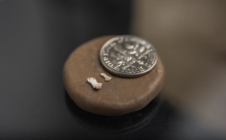
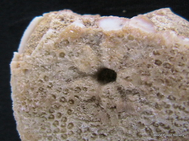
At Northern Illinois University, Dan Gebo opens a cabinet and pulls out a drawer full of thin plastic cases filled with clear gelatin capsules. Inside each numbered capsule is a tiny fossil — some are so small they rival the diminutive size of a mustard seed.
It’s hard to imagine that anyone would be able to recognize these flecks as fossils, much less link them to an ancient world that was very different from our own, yet has quite a bit to do with us — or the evolution of us.
The nearly 500 finger and toe bones belonged to tiny early primates — some half the size of a mouse. During the mid-Eocene period, about 45 million years ago, they lived in tree canopies and fed on fruit and insects in a tropical rainforest in what is now China.
The fossilized phalanges are described in detail in a new study by Gebo and colleagues, published online this fall ahead of print in the Journal of Human Evolution.
The fossils provide further evidence that early anthropoids were minuscule creatures.
Credit: Northern Illinois University
Representing nine different taxonomic families of primates and as many as 25 species, the specimens include numerous fossils attributed to Eosimias, the very first anthropoid known to date, and three fossils attributed to a new and much more advanced anthropoid. The anthropoid lineage would later include monkeys, apes and humans.
“The fossils are extraordinarily small, but in terms of quantity this is the largest single assemblage of fossil primate finger and toe specimens ever recorded,” said Gebo, an NIU professor of anthropology and biology who specializes in the study of primate anatomy.
All of the finger and toe fossils imply tree-dwelling primates with grasping digits in both hands and feet. Many of the smaller fossils are between 1 and 2 millimeters in length, and the animals would have ranged in full body size from 10 to 1,000 grams (0.35 to 35.3 ounces).
“The new study provides further evidence that early anthropoids were minuscule creatures, the size of a mouse or smaller,” Gebo said. “It also adds to the evidence pointing toward Asia as the initial continent for primate evolution. While apes and fossil humans do come from Africa, their ancestors came from Asia.”
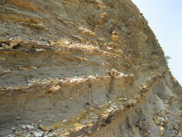
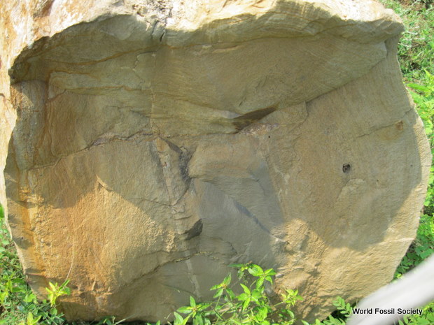
The newly described fossils were originally recovered from a commercial quarry near the village of Shanghuang in the southern Jiangsu Province of China, about 100 miles west of Shanghai. In recent decades, Shanghuang has become well-known among paleontologists.
“Shanghuang is truly an amazingly diverse fossil primate locality, unequaled across the Eocene,” Gebo said. “Because no existing primate communities show this type of body-size distribution, the Shanghuang primate fauna emphasizes that past ecosystems were often radically different from those we are familiar with today.”
Co-author Christopher Beard, a paleontologist at the University of Kansas in Lawrence who has been working on Shanghuang fossils for 25 years, said the limestone in the quarry is of Triassic age — from the very beginning of the Age of Dinosaurs some 220 million years ago. Owing to a subsequent phase of erosion, the limestone developed large fissures containing fossil-rich sediments dating to the middle Eocene, after dinosaurs went extinct.
In the early 1990s, more than 10 tons of fossil-bearing matrix were collected from the fissures and shipped to the Institute of Vertebrate Paleontology and Paleoanthropology in Beijing and the Carnegie Museum of Natural History in Pittsburgh. There, the matrix was washed and screened, yielding fossil bones and teeth from ancient mammals, many of which remain to be identified.
“Because of commercial exploitation of the quarry site, the fossil-bearing fissure-fillings at Shanghuang are now exhausted,” Beard said. “So, the fossils that we currently have are all that will ever be found from this site.”
Gebo was initially recruited during the late 1990s to spearhead research on primate limb and ankle bones from Shanghuang. That led to two publications in 2000, when he and colleagues first announced the discovery of 45 million-year-old, thumb-length primates, the smallest ever recovered, from this same site. The work identifying body parts also helped cement the status of Eosimias, first identified by Beard on the basis of jaw fragments discovered at the site, as an extremely primitive anthropoid lying at the very beginning of our lineage’s evolutionary past.
In more recent years, Gebo found additional specimens, sifting through miscellaneous elements from Shanghuang both at the Carnegie Museum and the University of Kansas. He brought the delicate and minuscule finger and toe fossils to NIU for study using traditional and electron-scanning microscopes.
The fossils that endured the millennia may be small but still have a story to tell. “We can actually identify different types of primates from the shapes of their fingers and toes,” Gebo said.
Primates are mammals, characterized by having bigger brains, grasping hands and feet, nails instead of claws and eyes located in the front of the skull. Living prosimians, or living lower primates, include lemurs and tarsiers, and have broader fingertips. In contrast, most living anthropoids, also known as higher primates, have narrow fingertips.
Fossils from the unnamed advanced anthropoid are narrow, Gebo said.
“These are the earliest known examples of those narrow fingers and toes that are key to anthropoid evolution,” he added. “We can see evolution occurring at this site, from the broader finger or toe tips to more narrow.”
Unlike other prehistoric forests across the globe that have a mixture of large and small primates, Shanghuang’s fossil record is unique in being nearly absent of larger creatures.
The unusual size distribution is likely the result of a sampling bias, Gebo said. Researchers might be missing the larger primate fauna because of processes affecting fossil preservation, and for similar reasons scientists at other Eocene localities could be missing the small-sized fauna.
“Many of the fossil specimens from Shanghuang show evidence of partial digestion by predatory birds, which may have specialized on preying upon the small primates and other mammals that are so common at Shanghuang, thus explaining the apparent bias toward small fossil species there,” Beard added.
Some of the primate fossils found in Shanghuang are found in other countries. Eosimias fossils have been recovered in Myanmar, for example. But Shanghuang stands out because of the presence of more advanced anthropoids and the sheer diversity of primates.
“You don’t find all of these fossil primates in one place except at Shanghuang,” Gebo said.


 November 20th, 2017
  Riffin
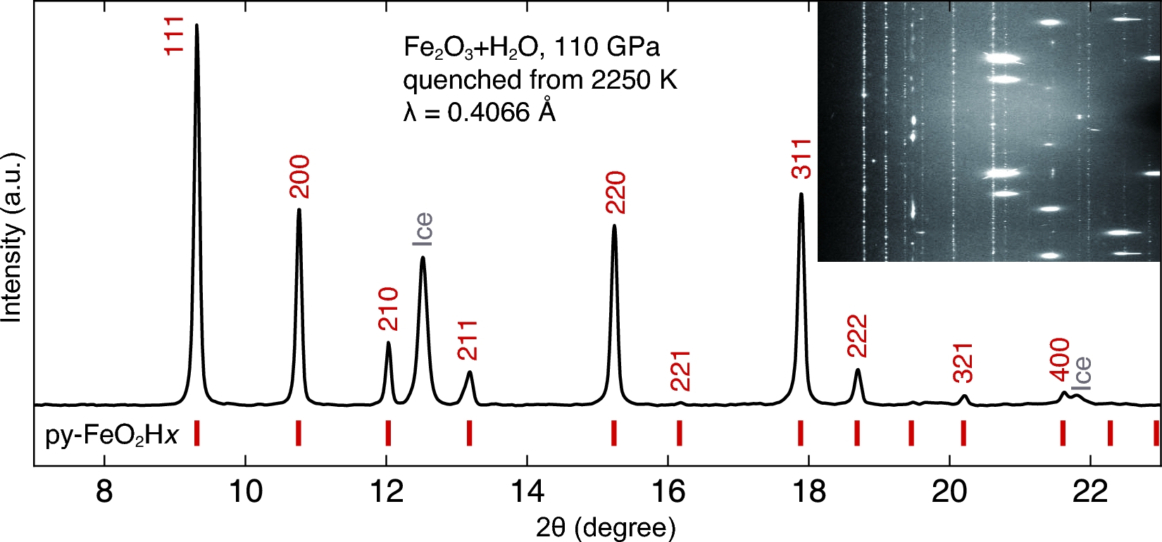
 ![XRD pattern of reaction products of iron and water. Iron powder was compressed in H2O to 96 GPa, heated up to 2200 K for 5 minutes, and quenched to 300 K. The pattern was composed of the Py-phase (a = 4.370(3) Å), the quenchable high-temperature f.c.c. phase [44] of FeH (a = 3.397(4) Å) and excess ice VII. Inset figure is the caked diffraction pattern, showing the coexistence of the Py-phase (dotted reflections) and FeH (continuous reflections).](http://www.worldfossilsociety.org/wp-content/uploads/2017/11/151209183454_1_540x360-14.jpg)