A chance fossil discovery in Montana a decade ago has led to the identification of an audacious new species of horned dinosaur. The international research team that described the plant-eating dinosaur was led by a scientist at the Canadian Museum of Nature. The results are published today in the online science journal PLOS ONE.
The museum now houses the specimen in its national fossil collection, which includes some of the best examples of horned dinosaurs in the world. Museum palaeontologist Dr. Jordan Mallon completed the scientific analysis that pinned down the dinosaur as a new species. It is one among a growing number of newly discovered ceratopsids (four-legged dinosaurs generally characterized by horns on the face and elaborate head frills).
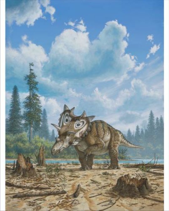
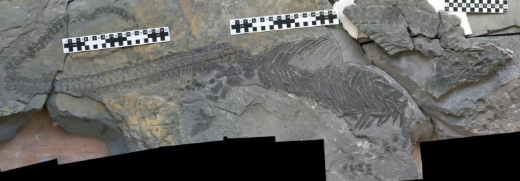
Artist illustration by Mike Skrepnick of Spiclypeus shipporum, a newly described genus and species of horned dinosaur. Here, the dinosaur roams across a floodplain 76 million years ago. The fossil was discovered in 2005 in the Judith River Formation in Montana.
Credit: Illustration by Mike Skrepnick © Mike Skrepnick.
Mallon has bestowed the scientific name Spiclypeus shipporum (spi-CLIP-ee-us ship-OR-um) on the dinosaur, which lived about 76 million year ago.Spiclypeus is a combination of two Latin words meaning “spiked shield,” referring to the impressive head frill and triangular spikes that adorn its margins. The name shipporum honours the Shipp family, on whose land the fossil was found near Winifred, Montana.
About half of the skull, as well as parts of the dinosaur’s legs, hips and backbone had been preserved in the silty hillside that once formed part of an ancient floodplain.
“This is a spectacular new addition to the family of horned dinosaurs that roamed western North America between 85 and 66 million years ago,” explains Mallon, who collaborated with researchers in Canada and the United States. “It provides new evidence of dinosaur diversity during the Late Cretaceous period from an area that is likely to yield even more discoveries.”
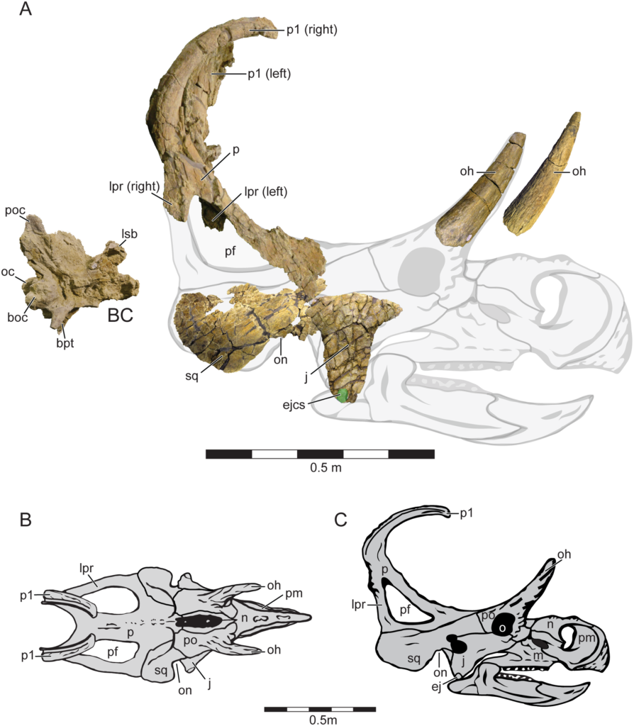
Holotype cranial Material and Cranial Reconstruction of Machairoceratops cronusi (UMNH VP 20550) gen. et sp. nov.
Recovered cranial elements of Machairoceratops in right-lateral view, shown overlain on a ghosted cranial reconstruction (A). The jugal, squamosal and braincase are all photo-reversed for reconstruction purposes. Machairoceratops cranial reconstruction in dorsal (B), and right-lateral (C) views. Green circle overlain on the ventral apex of the jugal highlights the size of the epijugal contact scar (ejcs). Abbreviations: BC, braincase; boc, basioccipital; bpt, basipterygoid process; ej, epijugal; ejcs, epijugal contact scar; j, jugal; lpr, lateral parietal ramus; lsb, laterosphenoid buttress; m, maxilla; n, nasal; o, orbit, oc, occipital condyle; oh, orbital horn; on, otic notch; p, parietal; pf, parietal fenestra; pm, premaxilla; po, postorbital; poc, paroccipital process; p1, epiparietal locus p1; sq, squamosal. Scale bars = 0.5 m.
What sets Spiclypeus shipporum apart from other horned dinosaurs such as the well-known Triceratops is the orientation of the horns over the eyes, which stick out sideways from the skull. There is also a unique arrangement to the bony “spikes” that emanate from the margin of the frill–some of the spikes curl forward while others project outward.
“In this sense, Spiclypeus is transitional between more primitive forms in which all the spikes at the back of the frill radiate outward, and those such asKosmoceratops in which they all curl forward,” says Mallon.
While the fossil now has a scientific moniker, it is more commonly known by its nickname “Judith,” after the Judith River geological formation where it was found. Until it was purchased by the museum in 2015, the fossil had remained in the official possession of Dr. Bill Shipp, who found it while exploring his newly acquired property in 2005.
Shipp invested time and money to excavate and prepare the bones, aided by volunteers and palaeontologists including the PLOS ONE study co-authors Chris Ott and Peter Larson. “Little did I know that the first time I went fossil hunting I would stumble on a new species,” explains Shipp, a retired nuclear physicist who became a fossil enthusiast after moving to his dinosaur rich area of Montana. “As a scientist, I’m really pleased that the Canadian Museum of Nature has recognized the dinosaur’s value, and that it can now be accessed by researchers around the world.”
Apart from the horns and frill bones that helped define Judith as a new species, close examination of some of its other bones reveal a story of a life lived with pain. Judith’s upper arm bone (humerus) shows distinct signs of arthritis and osteomyelitis (bone infection)–determined following analysis by Dr. Edward Iuliano, a radiologist at the Kadlec Regional Medical Cener, in Richland, Washington.
“If you look near the elbow, you can see great openings that developed to drain an infection. We don’t know how the bone became infected, but we can be sure that it caused the animal great pain for years and probably made its left forelimb useless for walking,” explains Mallon. Despite this trauma, analysis of the annual growth rings inside the dinosaur’s bones by the Royal Ontario Museum’s Dr. David Evans suggest it lived to maturity. The dinosaur would have been at least 10 years old when it died.
Mallon and his team note that there are now nine well-known dinosaur species (including Spiclypeus shipporum), from Montana’s Judith River Formation. Some are also found in Alberta, which has a much richer fossil record, but others such as Spiclypeus are unique to Montana. Significantly, Mallon says that none of the species are shared with more southerly states, suggesting that dinosaur faunas in western North America were highly localized about 76 million years ago. Mallon’s prior research has shown that such species-rich communities may have been enabled by dietary specializations among the herbivores, a phenomenon more commonly known as niche partitioning.
A public exhibit about Spiclypeus shipporum, will open May 24 at the Canadian Museum of Nature in Ottawa. It will include a reconstruction of the dinosaur’s skull, the diseased humerus, and other bones from this amazing fossil find.
Citation:Canadian Museum of Nature. “New horned dinosaur species with ‘spiked shield’.” ScienceDaily. ScienceDaily, 18 May 2016. <www.sciencedaily.com/releases/2016/05/160518152908.htm
@WFS,World Fossil Society,Riffin T Sajeev,Russel T Sajeev


 June 8th, 2016
  Riffin


![Seeing small areas of the Moon at 50 cm per pixel often presents unexpected views, and sometimes it is hard to interpret the geology at first glance, much less what is up and what is down! What are the white streaks? How did they get there? Image is 600 meters wide, from NAC frame M109624226L [NASA/GSFC/Arizona State University].](http://www.worldfossilsociety.org/wp-content/uploads/2016/06/M109624226LE_thumb.png)