Atopodentatus unicus: Bizarre New Fossil Reptile Discovered in China

Dr Xiao-Chun Wu and his colleagues named the new prehistoric creature Atopodentatus unicus and suggest it belonged to a group of reptiles called the sauropterygians.

“Generic name is derived from the Latin atopo for the peculiar dentition and dentatus for teeth; the specific name is derived from the Latin unicus for its unique morphology,” the scientists said in a paper published in the journal Naturwissenschaften.

This is an artist’s impression of Atopodentatus unicus. Image credit: © Nobu Tamura, 2014 (spinops.blogspot.com).

This is an artist’s impression of Atopodentatus unicus. Image credit: © Nobu Tamura, 2014 (spinops.blogspot.com).

Atopodentatus unicus measured about 3 m long and had a long body, short neck and special adaptations for a fully aquatic or semi-aquatic lifestyle.

Its nearly complete skeleton and a left lateral side of the skull were collected from the middle Triassic of Guanling Formation near Daaozi village, Yunnan, China.

The most distinguishing characteristic of Atopodentatus unicus is its bizarre mouth.

Atopodentatus unicus. Image credit: Long Cheng et al.

Atopodentatus unicus. Image credit: Long Cheng et al.

On each side of the mouth, the reptile had about 35 small needle-like teeth in the front of the upper jaw, about 140 small needle-like teeth in the rest of the upper jaw (at least 100 in the horizontal portion and around 35 in the vertical portion), and more than 190 teeth in the lower jaw (about 100 in the horizontal portion and 90 in the shovel-headed anterior end). The teeth were covered by a layer of enamel.

According to Dr Wu’s team, Atopodentatus unicus may have been adapted to a way of bottom-filter feeding in water.

“It is obvious that such delicate teeth are not strong enough to catch prey, but were probably used as a barrier to filter microorganisms or benthic invertebrates such as sea worms,” they said.

“These were collected by the specialized jaws, which may have functioned as a shovel or pushdozer and a grasper or scratcher.”

Source:article by Sergio Prostak

Earth’s mantle plasticity explained: Missing mechanism for deforming olivine-rich rocks

Earth’s mantle is a solid layer that undergoes slow, continuous convective motion. But how do these rocks deform, thus making such motion possible, given that minerals such as olivine (the main constituent of the upper mantle) do not exhibit enough defects in their crystal lattice to explain the deformations observed in nature? A team led by the Unité Matériaux et Transformations (CNRS/Université Lille 1/Ecole Nationale Supérieure de Chimie de Lille) has provided an unexpected answer to this question. It involves little known and hitherto neglected crystal defects, known as ‘disclinations’, which are located at the boundaries between the mineral grains that make up rocks. Focusing on olivine, the researchers have for the first time managed to observe such defects and model the behavior of grain boundaries when subjected to a mechanical stress.

Optical microscopy image in cross polarized light of a natural olivine polycrystal (Oman mylonite). Credit: S. Demouchy, Montpellier

Optical microscopy image in cross polarized light of a natural olivine polycrystal (Oman mylonite).
Credit: S. Demouchy, Montpellier

The findings, which have just been published in Nature, go well beyond the scope of the geosciences: they provide a new, extremely powerful tool for the study of the dynamics of solids and for the materials sciences in general.

Earth continuously releases its heat via convective motion in Earth’s mantle, which underlies the crust. Understanding this convection is therefore fundamental to the study of plate tectonics. The mantle is made up of solid rocks. In order for convective motion to occur, it must be possible for the crystal lattice of these rocks to deform. Until now, this was a paradox that science was unable to fully resolve. While defects in the crystal lattice, called dislocations, provide a very good explanation of the plasticity of metals, they are insufficient to explain the deformations undergone by certain mantle rocks.

The researchers suspected that the solution was to be found at the boundaries between the mineral grains that make up rocks. However, they lacked the conceptual tools needed to describe and model the role played by these boundaries in the plasticity of rocks. Researchers at the Unité Matériaux et Transformations (CNRS/Université Lille 1/Ecole Nationale Supérieure de Chimie de Lille) in collaboration with researchers at the Laboratoire Géosciences Montpellier (CNRS/Université Montpellier 2) and the Laboratoire d’Etude des Microstructures et de Mécanique des Matériaux (CNRS/Université de Lorraine/Arts et Métiers ParisTech/Ecole Nationale d’Ingénieurs de Metz) have now explained this role. They have shown that the crystal lattice of the grain boundaries exhibits highly specific defects known as ‘disclinations’, which had hitherto been neglected. The researchers succeeded in observing them for the first time in samples of olivine (which makes up as much as 60% of the upper mantle) by using an electron microscope and specific image processing. They even went further: based on a mathematical model, they showed that these disclinations provided an explanation for the plasticity of olivine. When mechanical stress is applied, the disclinations enable the grain boundaries to move, thus allowing olivine to deform in any direction. Flow in the mantle is thus no longer incompatible with its rigidity.

This research goes beyond explaining the plasticity of rocks in Earth’s mantle: it is a major step forward in materials science. Consideration of disclinations should provide scientists with a new tool to explain many phenomena related to the mechanics of solids. The scientists intend to continue their research into the structure of grain boundaries, not only in other minerals but also in other solids such as metals.

Insights into plate tectonics, the forces behind earthquakes, volcanoes

The Earth’s outer layer is made up of a series of moving, interacting plates whose motion at the surface generates earthquakes, creates volcanoes and builds mountains. Geoscientists have long sought to understand the plates’ fundamental properties and the mechanisms that cause them to move and drift, and the questions have become the subjects of lively debate.

A study published online Feb. 27 by the journal Science is a significant step toward answering those questions.

Researchers led by Caroline Beghein, assistant professor of earth, planetary and space sciences in UCLA’s College of Letters and Science, used a technique called seismic tomography to study the structure of the Pacific Plate — one of eight to 12 major plates at the surface of the Earth. The technique enabled them to determine the plate’s thickness, and to image the interior of the plate and the underlying mantle (the layer between the Earth’s crust and outer core), which they were able to relate to the direction of flow of rocks in the mantle.

“Rocks deform and flow slowly inside the Earth’s mantle, which makes the plates move at the surface,” said Beghein, the paper’s lead author. “Our research enables us to image the interior of the plate and helps us figure out how it formed and evolved.” The findings might apply to other oceanic plates as well.

Even with the new findings, Beghein said, the fundamental properties of plates “are still somewhat enigmatic.”

Seismic tomography is similar to commonly used medical imaging techniques like computed tomography, or CT, scans. But instead of using X-rays, seismic tomography employs recordings of the seismic waves generated by earthquakes, allowing scientists to detect variations in the speed of seismic waves inside the Earth. Those variations can reveal different layers within the mantle, and can help scientists determine the temperature and chemistry of the mantle rocks by comparing observed variations in wave speed with predictions from other types of geophysical data.

Seismologists often use other types of seismic data to identify this layering: They detect seismic waves that bounce off the interface that separates two layers. In their study, Beghein and co-authors compared the layering they observed using seismic tomography with the layers revealed by these other types of data. Comparing results from the different methods is a continuing challenge for geoscientists, but it is an important part of helping them understand the Earth’s structure.

“We overcame this challenge by trying to push the observational science to the highest resolutions, allowing us to more readily compare observations across datasets,” said Nicholas Schmerr, the study’s co-author and an assistant research scientist in geology at the University of Maryland.

The researchers were the first to discover that the Pacific Plate is formed by a combination of mechanisms: The plate thickens as the rocks of the mantle cool, the chemical makeup of the rocks that form the plate changes with depth, and the mechanical behavior of the rocks change with depth and their proximity to where the plate is being formed at the mid-ocean ridge.

The Earth's outer layer is broken into moving, interacting plates whose motion at the surface generates most earthquakes, creates volcanoes and builds mountains. In this image, the orange layer represents the deformable, warm asthenosphere in which there is active mantle flow. The green layer is the lithospheric plate, which forms at the mid ocean ridge, then cools down and thickness as it moves away from the ridge. The cooling of the plate overprints a compositional boundary that forms at the ridge by dehydration melting and is preserved as the plate ages. The more easily deformable, hydrated rocks align with mantle flow. The directions of past and present-day mantle flow can be detected by seismic waves, and changes in the alignment of the rocks inside and at the bottom of the plate can be used to identify layering. [show less] Credit: Nicholas Schmerr/University of Maryland

The Earth’s outer layer is broken into moving, interacting plates whose motion at the surface generates most earthquakes, creates volcanoes and builds mountains. In this image, the orange layer represents the deformable, warm asthenosphere in which there is active mantle flow. The green layer is the lithospheric plate, which forms at the mid ocean ridge, then cools down and thickness as it moves away from the ridge. The cooling of the plate overprints a compositional boundary that forms at the ridge by dehydration melting and is preserved as the plate ages. The more easily deformable, hydrated rocks align with mantle flow. The directions of past and present-day mantle flow can be detected by seismic waves, and changes in the alignment of the rocks inside and at the bottom of the plate can be used to identify layering.
Credit: Nicholas Schmerr/University of Maryland

“By modeling the behavior of seismic waves in Earth’s mantle, we discovered a transition inside the plate from the top, where the rocks didn’t deform or flow very much, to the bottom of the plate, where they are more strongly deformed by tectonic forces,” Beghein said. “This transition corresponds to a boundary between the layers that we can image with seismology and that we attribute to changes in rock composition.”Oceanic plates form at ocean ridges and disappear into the Earth’s mantle, a process known as subduction. Among geoscientists, there is still considerable debate about what drives this evolution. Beghein and her research team advanced our understanding of how oceanic plates form and evolve as they age by using and comparing two sets of seismic data; the study revealed the presence of a compositional boundary inside the plate that appears to be linked to the formation of the plate itself.

Other co-authors of the research are Kaiqing Yuan and Zheng Xing, graduate students in UCLA’s Department of Earth, Planetary and Space Sciences.

Source: University of California – Los Angeles. “Insights into plate tectonics, the forces behind earthquakes, volcanoes.” ScienceDaily. ScienceDaily, 4 March 2014. <www.sciencedaily.com/releases/2014/03/140304113542.htm>.

Torvosaurus gurneyi: New dinosaur found in Portugal, largest terrestrial predator from Europe


A new dinosaur species found in Portugal may be the largest land predator discovered in Europe, as well as one of the largest carnivorous dinosaurs from the Jurassic, according to a paper published in PLOS ONE on March 5, 2014 by co-authors Christophe Hendrickx and Octavio Mateus from Universidade Nova de Lisboa and Museu da Lourinhã.

Scientists discovered bones belonging to this dinosaur north of Lisbon. They were originally believed to be Torvosaurus tanneri, a dinosaur species from North America. Closer comparison of the shin bone, upper jawbone, teeth, and partial tail vertebrae suggest to the authors that it may warrant a new species name, Torvosaurus gurneyi.

The new dinosaur species is estimated up to 10 meters long and 4-5 tons. Credit: Christophe Hendrickx; CC-BY

The new dinosaur species is estimated up to 10 meters long and 4-5 tons.
Credit: Christorphe Hendickx; CC-BY

T. gurneyi had blade-shaped teeth up to 10 cm long, which indicates it may have been at the top of the food chain in the Iberian Peninsula roughly 150 million years ago. The scientists estimate that the dinosaur could reach 10 meters long and weigh around 4 to 5 tons. The number of teeth, as well as size and shape of the mouth, may differentiate the European and the American Torvosaurus. The fossil of the upper jaw of T. tanneri has 11 or more teeth, while T. gurneyi has fewer than 11. Additionally, the mouth bones have a different shape and structure. The new dinosaur is the second species of Torvosaurus to be named.

“This is not the largest predatory dinosaur we know. Tyrannosaurus, Carcharodontosaurus, and Giganotosaurus from the Cretaceous were bigger animals,” said Christophe Hendrickx. “With a skull of 115 cm, Torvosaurus gurneyi was however one of the largest terrestrial carnivores at this epoch, and an active predator that hunted other large dinosaurs, as evidenced by blade shape teeth up to 10 cm.” Fossil evidences of closely related dinosaurs suggest that this large predator may have already been covered with proto-feathers. Recently described dinosaur embryos from Portugal are also ascribed to the new species of Torvosaurus.

Superbly preserved Fossil specimens in Daohugou Biota,Mangolia

Over the last two decades, huge numbers of fossils have been collected from the western Liaoning Province and adjacent parts of northeastern China, including exceptionally preserved feathered dinosaurs, early birds, and mammals. Most of these specimens are from the Cretaceous Period, including the famous Jehol Biota. However, in recent years many fossils have emerged from sites that are 30 million years earlier, from the Middle-Upper Jurassic Period, providing an exceptional window on life approximately 160 million years ago. A new paper published in latest issue of the Journal of Vertebrate Paleontology shows that several of these Jurassic sites are linked together by shared species and can be recognized as representing a single fossil fauna and flora, containing superbly preserved specimens of a diverse group of amphibian, mammal, and reptile species.

This fossil assemblage, newly named the Daohugou Biota after a village near one of the major localities in Inner Mongolia, China, dates from a time when many important vertebrate groups, including our own group, mammals, were undergoing evolutionary diversification. The Daohugou Biota makes an immense contribution to our understanding of vertebrate evolution during this period, with such notable creatures as the oldest known gliding mammal, another early mammal that may have swum with a beaver-like tail, the oldest dinosaurs preserved with feathers, and a pterosaur that represents an important transitional form between two major groups. As described by Dr. Corwin Sullivan, lead author of the study, “The Daohugou Biota gives us a look at a rarely glimpsed side of the Middle to Late Jurassic — not a parade of galumphing giants, but an assemblage of quirky little creatures like feathered dinosaurs, pterosaurs with ‘advanced’ heads on ‘primitive’ bodies, and the Mesozoic equivalent of a flying squirrel.”

Almost more impressive than the diversity of the biota is the preservation of many of the vertebrate specimens, including complete or nearly-complete skeletons associated with preserved soft tissues such as feathers, fur, skin or even, in some of the salamanders, external gills. Dr Yuan Wang, co-author of the study, explained, “The Daohugou amphibians are crucially important in the study of the phylogeny and early radiation of modern amphibian groups.”

This is the fossil of the salamander Chunerpeton showing not only the preserved skeleton but also the skin and even external gills. Credit: Society of Vertebrate Paleontology

This is the fossil of the salamander Chunerpeton showing not only the preserved skeleton but also the skin and even external gills.
Credit: Society of Vertebrate Paleontology

Dr. Paul Barrett, dinosaur researcher at the Natural History Museum, London, who was not involved with the study, commented, “Daohugou is proving to be one of the key sites for understanding the evolution of feathered dinosaurs, early mammals, and flying reptiles, due largely to the fantastic levels of preservation. Many of the fossils are stunning and offer vast amounts of information. There are only a handful of similar sites elsewhere in the world and this article represents the first comprehensive attempt to draw all of the relevant information together into a single benchmark paper.” Because the Daohugou Biota and the much better studied Jehol Biota are similar in preservational mode and geographic location, but separated by tens of millions of years, they give palaeontologists an outstanding, even unique, opportunity to study changes in the fauna of this region over a significant span of geological time and an important period in vertebrate evolution. As Dr. Sullivan further remarked, “The Cretaceous feathered dinosaurs of northeastern China have been astonishing palaeontologists and the public for almost two decades now, and the Daohugou Biota preserves their Jurassic counterparts in the same region. As prequels go, it’s pretty exciting.”

Source: Society of Vertebrate Paleontology. “Prequel outshines the original: Exceptional fossils of 160-million-year-old doahugou biota.” ScienceDaily. ScienceDaily, 4 March 2014.

How Earth might have looked: How a failed Saharan Atlantic Ocean rift zone sculped Africa’s margin

Break-up of the supercontinent Gondwana about 130 Million years ago could have lead to a completely different shape of the African and South American continent with an ocean south of today’s Sahara desert, as geoscientists from the University of Sydney and the GFZ German Research Centre for Geosciences have shown through the use of sophisticated plate tectonic and three-dimensional numerical modelling.

The study highlights the importance of rift orientation relative to extension direction as key factor deciding whether an ocean basin opens or an aborted rift basin forms in the continental interior.

For hundreds of millions of years, the southern continents of South America, Africa, Antarctica, Australia, and India were united in the supercontinent Gondwana. While the causes for Gondwana’s fragmentation are still debated, it is clear that the supercontinent first split along along the East African coast in a western and eastern part before separation of South America from Africa took place. Today’s continental margins along the South Atlantic ocean and the subsurface graben structure of the West African Rift system in the African continent, extending from Nigeria northwards to Libya, provide key insights on the processes that shaped present-day Africa and South America.

Christian Heine (University of Sydney) and Sascha Brune (GFZ) investigated why the South Atlantic part of this giant rift system evolved into an ocean basin, whereas its northern part along the West African Rift became stuck.


A hypothetical model of the circum-Atlantic region at present-day, if Africa had split into two parts along the West African Rift system. Here, the north-west part of present day Africa would have moved with the South American continent, forming a "Saharan Atlantic ocean". Credit: Sascha Brune/Christian Heine

A hypothetical model of the circum-Atlantic region at present-day, if Africa had split into two parts along the West African Rift system. Here, the north-west part of present day Africa would have moved with the South American continent, forming a “Saharan Atlantic ocean”.
Credit: Sascha Brune/Christian Heine

“Extension along the so-called South Atlantic and West African rift systems was about to split the African-South American part of Gondwana North-South into nearly equal halves, generating a South Atlantic and a Saharan Atlantic Ocean,” geoscientist Sascha Brune explains. “In a dramatic plate tectonic twist, however, a competing rift along the present-day Equatorial Atlantic margins, won over the West African rift, causing it to become extinct, avoiding the break-up of the African continent and the formation of a Saharan Atlantic ocean.”

The complex numerical models provide a strikingly simple explanation: the larger the angle between rift trend and extensional direction, the more force is required to maintain a rift system. The West African rift featured a nearly orthogonal orientation with respect to westward extension which required distinctly more force than its ultimately successful Equatorial Atlantic opponent.

Source: Helmholtz Centre Potsdam – GFZ German Research Centre for Geosciences. “How Earth might have looked: How a failed Saharan Atlantic Ocean rift zone sculped Africa’s margin.” ScienceDaily. ScienceDaily, 28 February 2014. <www.sciencedaily.com/releases/2014/02/140228210545.htm>.

Cyanobacteria sheds light on how complex life evolved on earth

Plankton in Earth’s oceans received a huge boost when microorganisms capable of creating soluble nitrogen ‘fertilizer’ directly from the atmosphere diversified and spread throughout the open ocean. This event occurred at around 800 million years ago and it changed forever how carbon was cycled in the ocean.

It has long been believed that the appearance of complex multicellular life towards the end of the Precambrian (the geologic interval lasting up until 541 million years ago) was facilitated by an increase in oxygen, as revealed in the geological record. However, it has remained a mystery as to why oxygen increased at this particular time and what its relationship was to ‘Snowball Earth’ — the most extreme climatic changes Earth has ever experienced — which were also taking place around then.

This new study shows that it could in fact be what was happening to nitrogen at this time that helps solve the mystery.

The researchers, led by Dr Patricia Sanchez-Baracaldo of the University of Bristol, used genomic data to reconstruct the relationships between those cyanobacteria whose photosynthesis in the open ocean provided oxygen in quantities sufficient to be fundamental in the development of complex life on Earth.

Some of these cyanobacteria were also able to transform atmospheric nitrogen into bioavailable nitrogen in sufficient quantities to contribute to the marine nitrogen cycle, delivering ‘nitrogen fertiliser’ to the ecosystem. Using molecular techniques, the team were able to date when these species first appeared in the geological record to around 800 million years ago.

 A plankton bloom in the Capricorn Channel off the Queensland coast of Australia - Trichodesmium — a photosynthetic cyanobacteria and nitrogen fixer. Credit: Astronaut photograph ISS005-E-21572 taken December 3, 2002, provided by NASA's Earth Sciences and Image Analysis

A plankton bloom in the Capricorn Channel off the Queensland coast of Australia – Trichodesmium — a photosynthetic cyanobacteria and nitrogen fixer.
Credit: Astronaut photograph ISS005-E-21572 taken December 3, 2002, provided by NASA’s Earth Sciences and Image Analysis

Dr Sanchez-Baracaldo, a Royal Society Dorothy Hodgkin Research Fellow in Bristol’s Schools of Biological and Geographical Sciences said: “We have known that oxygenic photosynthesis — the process by which microbes fix carbon dioxide into carbohydrates, splitting water and releasing oxygen as a by-product — first evolved in freshwater habitats more than 2.3 billion years ago. But it wasn’t until around 800 million years ago that these oxygenating cyanobacteria were able to colonise the vast oceans (two thirds of our planet) and be fertilised by enough bioavailable nitrogen to then produce oxygen — and carbohydrate food — at levels high enough to facilitate the next ‘great leap forward’ towards complex life.

“Our study suggests that it may have been the fixing of this nitrogen ‘fertiliser’ in the oceans at this time that played a pivotal role in this key moment in the evolution of life on Earth.”

Co-author, Professor Andy Ridgwell said: “The timing of the spread in nitrogen fixers in the open ocean occurs just prior to global glaciations and the appearance of animals. Although further work is required, these evolutionary changes may well have been related to, and perhaps provided a trigger for, the occurrence of extreme glaciation around this time as carbon was now being buried in the sediments on a much larger scale.”

Dr Sanchez-Baracaldo added: “It’s very exciting to have been able to use state of the art genetic techniques to help solve an age-old mystery concerning one of the most important and pivotal moments in the evolution of life on Earth. In recent years, genomic data has been helping re-tell the story of the origins of life with increasing clarity and accuracy. It is a privilege to be contributing to our understanding of how microorganisms have contributed to make our planet habitable.”

Fossilized whale skeletons unearths in Chilean highway project

The whales were found more than 120 feet above sea level, about two-thirds of a mile from the ocean, in ancient sandstones below what is now the northbound lane of the Pan-American Highway in the Atacama region of northern Chile.Highway construction workers found the first skeletons. They called a nearby museum, and said: We found bones.

It has turned out to be one of most extraordinary marine mammal fossil sites on the planet. Scientists discovered more than 40 skeletons, most of them baleen whales, strewn across a small area in four distinct levels, suggesting four separate mass strandings over a period of more than 10,000 years. In one spot, the skeletons of two adult whales lay on top of the skeleton of a juvenile whale.

The site includes two seals, an extinct species of sperm whale, a walrus-like toothed whale, and an aquatic sloth. Most animals were belly-up, suggesting death at sea or shortly after washing ashore, said Nick Pyenson, curator of fossil marine mammals at the Smithsonian’s National Museum of Natural History.

Pyenson is the lead author of a paper describing the assemblage of cetacean fossils, published Tuesday evening in the journal Proceedings of the Royal Society B.

The likely cause of the mass strandings were harmful algal blooms, sometimes known as red tide. That’s the only obvious mechanism that could have repeatedly wiped out a variety of animals high in the food chain, Pyenson said.

The scientists estimate the age of the rock formation, and thus of the skeletons, at 6 million to 9 million years. In the time since, the tidal cove where the whales and other animals washed ashore has been lifted high above sea level by the immense tectonic forces that also created the Andes.

The existence of whale bones in this coastal desert has been known for years, and is reflected in the name of the site: Cerro Ballena — “Whale Hill.” But when the highway expansion began in 2010, and scientists were alerted to this new cache of fossils, they were astonished at the profusion of intact, highly articulated skeletons that showed no sign of having been scavenged before they were buried and fossilized.

An ancient whale graveyard lies amid the Pan-American Highway project in Chile in 2011. Scientists unearthed the bones of more than 40 marine mammals, including two seals, an aquatic sloth and an extinct species of sperm whale.


An ancient whale graveyard lies amid the Pan-American Highway project in Chile in 2011. Scientists unearthed the bones of more than 40 marine mammals, including two seals, an aquatic sloth and an extinct species of sperm whale.

“I was blown away the first time I saw it. I didn’t appreciate the scale of what was described to me,” said Pyenson.

The discovery of the site has been previously reported, but the new paper, which features 14 co-authors from the U.S., Chile and Brazil, is the most comprehensive review of the fossils and their significance.

Whale fossils are usually found singularly, said Richard Norris, a paleontologist at Scripps Institution of Oceanography who was not affiliated with the new research. He said the Cerro Ballena site is an extraordinary discovery.

“Whale fossils are not common. Having articulated whale fossils is even less common,” he said. And moreover, a trove of fossils that includes animals of different ages “is vanishingly rare.”

Unfortunately, the fossils were in the path of the highway. Chile has an booming mining industry — the extraction of fossil treasure of a different sort. The bones had to be moved.

“I don’t wish a whale skeleton on anyone – it’s a logistical nightmare,” Pyenson said. “It’s a big problem just to excavate one, let alone that number.”

Pyenson enlisted a team of technicians nicknamed the “laser cowboys” to visit Chile and create a 3-D digital record of the arrangement of the skeletons. Only then were the bones excavated and shipped to museums. The 3-D data will enable the printing of replicas of the skeletons.

The digital work by Pyenson and his team is a major step forward, said Jeremy Goldbogen, a marine biologist at the Hopkins Marine Station of Stanford University who was not part of the research: “He’s really bringing paleontology into the future with these new techniques.”

Pyenson believes that the Cerro Ballena site is a paleontological treasure on par with the La Brea Tar Pits — from which the remains of mammoths and other extinct megafauna have been retrieved — and Dinosaur National Monument. He said there could be hundreds of other fossils, including many whales, still hidden in the sand and rock along the highway

Zircon Crystal reveals “cool early Earth” at 4.4 billion years.

With the help of a tiny fragment of zircon extracted from a remote rock outcrop in Australia, the picture of how our planet became habitable to life about 4.4 billion years ago is coming into sharper focus.

Writing today (Feb. 23, 2014) in the journal Nature Geoscience, an international team of researchers led by University of Wisconsin-Madison geoscience Professor John Valley reveals data that confirm the Earth’s crust first formed at least 4.4 billion years ago, just 160 million years after the formation of our solar system. The work shows, Valley says, that the time when our planet was a fiery ball covered in a magma ocean came earlier.

“This confirms our view of how the Earth cooled and became habitable,” says Valley, a geochemist whose studies of zircons, the oldest known terrestrial materials, have helped portray how the Earth’s crust formed during the first geologic eon of the planet. “This may also help us understand how other habitable planets would form.”

This is a timeline of the history of our planet places the formation of the Jack Hills zircon and a "cool early Earth" at 4.4 billion years. Credit: Andree Valley

This is a timeline of the history of our planet places the formation of the Jack Hills zircon and a “cool early Earth” at 4.4 billion years.
Credit: Andree Valley

The new study confirms that zircon crystals from Western Australia’s Jack Hills region crystallized 4.4 billion years ago, building on earlier studies that used lead isotopes to date the Australian zircons and identify them as the oldest bits of the Earth’s crust. The microscopic zircon crystal used by Valley and his group in the current study is now confirmed to be the oldest known material of any kind formed on Earth.

The study, according to Valley, strengthens the theory of a “cool early Earth,” where temperatures were low enough for liquid water, oceans and a hydrosphere not long after the planet’s crust congealed from a sea of molten rock. “The study reinforces our conclusion that Earth had a hydrosphere before 4.3 billion years ago,” and possibly life not long after, says Valley.

The study was conducted using a new technique called atom-probe tomography that, in conjunction with secondary ion mass spectrometry, permitted the scientists to accurately establish the age and thermal history of the zircon by determining the mass of individual atoms of lead in the sample. Instead of being randomly distributed in the sample, as predicted, lead atoms in the zircon were clumped together, like “raisins in a pudding,” notes Valley.

The clusters of lead atoms formed 1 billion years after crystallization of the zircon, by which time the radioactive decay of uranium had formed the lead atoms that then diffused into clusters during reheating. “The zircon formed 4.4 billion years ago, and at 3.4 billion years, all the lead that existed at that time was concentrated in these hotspots,” Valley says. “This allows us to read a new page of the thermal history recorded by these tiny zircon time capsules.”

The formation, isotope ratio and size of the clumps — less than 50 atoms in diameter — become, in effect, a clock, says Valley, and verify that existing geochronology methods provide reliable and accurate estimates of the sample’s age. In addition, Valley and his group measured oxygen isotope ratios, which give evidence of early homogenization and later cooling of the Earth.

“The Earth was assembled from a lot of heterogeneous material from the solar system,” Valley explains, noting that the early Earth experienced intense bombardment by meteors, including a collision with a Mars-sized object about 4.5 billion years ago “that formed our moon, and melted and homogenized the Earth. Our samples formed after the magma oceans cooled and prove that these events were very early.”

How river rocks round? Geophysicist teams joins with mathematicians

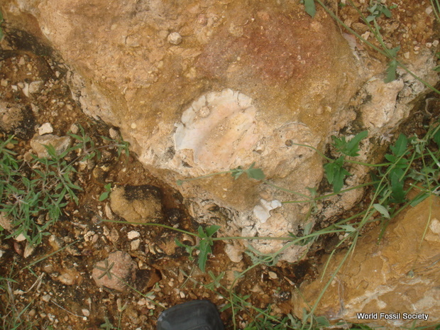
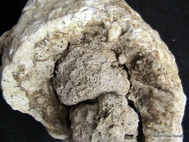
For centuries, geologists have recognized that the rocks that line riverbeds tend to be smaller and rounder further downstream. But these experts have not agreed on the reason these patterns exist. Abrasion causes rocks to grind down and become rounder as they are transported down the river. Does this grinding reduce the size of rocks significantly, or is it that smaller rocks are simply more easily transported downstream?

The team devised a mathematical model to show that a rock becomes round (top row) and then shrinks (bottom row). Credit: University of Pennsylvania

The team devised a mathematical model to show that a rock becomes round (top row) and then shrinks (bottom row).
Credit: University of Pennsylvania

A new study by the University of Pennsylvania’s Douglas Jerolmack, working with mathematicians at Budapest University of Technology and Economics, has arrived at a resolution to this puzzle. Contrary to what many geologists have believed, the team’s model suggests that abrasion plays a key role in upholding these patterns, but it does so in a distinctive, two-phase process. First, abrasion makes a rock round. Then, only when the rock is smooth, does abrasion act to make it smaller in diameter.

“It was a rather remarkable and simple result that helps to solve an outstanding problem in geology,” Jerolmack said.

Not only does the model help explain the process of erosion and sediment travel in rivers, but it could also help geologists answer questions about a river’s history, such as how long it has flowed. Such information is particularly interesting in light of the rounded pebbles recently discovered on Mars — seemingly evidence of a lengthy history of flowing rivers on its surface.

Jerolmack, an associate professor in Penn’s Department of Earth and Environmental Science, lent a geologist’s perspective to the Hungarian research team, composed of Gábor Domokos, András Sipos and Ákos Török.

Their work is to be published in the journal PLOS ONE.

Prior to this study, most geologists did not believe that abrasion could be the dominant force responsible for the gradient of rock size in rivers because experimental evidence pointed to it being too slow a process to explain observed patterns. Instead, they pointed to size-selective transport as the explanation for the pattern: small rocks being more easily transported downstream.

The Budapest University researchers, however, approached the question of how rocks become round purely as a geometrical problem, not a geological one. The mathematical model they conceived formalizes the notion, which may seem intuitive, that sharp corners and protruding parts of a rock will wear down faster than parts that protrude less.

The equation they conceived relates the erosion rate of any surface of a pebble with the curvature of the pebble. According to their model, areas of high curvature erode quickly, and areas of zero or negative curvature do not erode at all.

The math that undergirds their explanation for how pebbles become smooth is similar to the equation that explains how heat flows in a given space; both are problems of diffusion.

“Our paper explains the geometrical evolution of pebble shapes,” said Domokos, “and associated geological observations, based on an analogy with an equation that describes the variation of temperature in space and time. In our analogy, temperature corresponds to geometric (or Gaussian) curvature. The mathematical root of our paper is the pioneering work of mathematician Richard Hamilton on the Gauss curvature flow.”

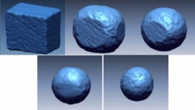
From this geometric model comes the novel prediction that abrasion of rocks should occur in two phases. In the first phase, protruding areas are worn down without any change in the diameter of the pebble. In the second phase, the pebble begins to shrink.

“If you start out with a rock shaped like a cube, for example,” Jerolmack said, “and start banging it into a wall, the model predicts that under almost any scenario that the rock will erode to a sphere with a diameter exactly as long as one of the cube’s sides. Only once it becomes a perfect sphere will it then begin to reduce in diameter.”

The research team also completed an experiment to confirm their model, taking a cube of sandstone and placing it in a tumbler and monitoring its shape as it eroded.

“The shape evolved exactly as the model predicted,” Jerolmack said.

The finding has a number of implications for geologic questions. One is that rocks can lose a significant amount of their mass before their diameter starts to shrink. Yet geologists typically measure river rock size by diameter, not weight.

“If all we’re doing in the field is measuring diameter, then we’re missing the whole part of shape evolution that can occur without any change in diameter,” Jerolmack said. “We’re underestimating the importance of abrasion because we’re not measuring enough about the pebble.”

As a result, Jerolmack noted that geologists may also have been underestimating how much sand and silt arises because of abrasion, the material ground off of the rocks that travel downstream.

“The fine particles that are produced by abrasion are the things that go into producing the floodplain downstream in the river; it’s the sand that gets deposited on the beach; it’s the mud that gets deposited in the estuary,” he said.

With this new understanding of how the process of abrasion proceeds, researchers can address other questions about river flow — both here on Earth and elsewhere, such as on Mars, where NASA’s rover Curiosity recently discovered rounded pebbles indicative of ancient river flow.

“If you pluck a pebble out of a riverbed,” Jerolmack said, “a question you might like to answer, how far has this pebble traveled? And how long has it taken to reach this place?”

Such questions are among those that Jerolmack and colleagues are now asking.

“If we know something about a rock’s initial shape, we can model how it went from its initial shape to the current one,” he said. “On Mars, we’ve seen evidence of river channels, but what everyone wants to know is, was Mars warm and wet for a long time, such that you could have had life? If I can say how long it took for this pebble to grind down to this shape, I can put a constraint on how long Mars needed to have stable liquid water on the surface.”