

 September 27th, 2012
  riffin
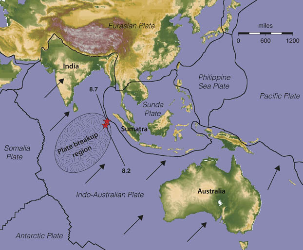
 Breaking up is hard to do. Even for Earth’s tectonic plates, separation is studded with sudden releases of pent up stress, such as the twin tremors that rocked the Indian Ocean on April 11, 2012.
The magnitude 8.7 and 8.2 earthquakes that struck off the coast of Sumatra that day herald the breakup of the Indo-Australian plate along an unclear boundary beneath the Indian Ocean southeast of India, according to two studies published online today in Nature.
boundaries of Earth’s tectonic plates near the epicenters
In one of the reports, seismologists from the University of Utah and University of California, Santa Cruz, say the main shock—the combined outcries of four separate faults rupturing in a span of 160 seconds—measured 8.7 in magnitude. That’s about 40 times larger than the previous estimate of 8.6. The 8.2-magnitude quake followed along a fifth fault two hours later.
Two of the largest strike-slip earthquakes ever recorded, these earthquakes struck where the Indo-Australian plate is being torn asunder as it marches to the northeast. The trouble happens because the west of breakup region is not keeping pace with the segment to the east. The western portion of the plate is slowed by its ongoing collision with Asia, whle eastern part of the plate moves relatively unimpeded as it dives, or subducts, under the island of Sumatra.
It’s been five years since an 800-mile-long (1,300 km) section of colliding plates in Earth’s crust unzipped and unleashed a 9.3 megathrust earthquake from Sumatra to the Andaman Islands. The rupture moved a block of earth as long as California about 30 feet. At least 230,000 people perished from the quake and the tsunamis that followed. We’re remembering the disaster, as well as looking at the many lessons and discoveries been gleaned from it — lessons that should never be forgotten.
By changing stress patterns in the earth’s crust, that 2004 catastrophe probably helped to trigger the 2012 quakes, which were much less upsetting from humanity’s point of view: only ten people are known to have died as a result.
The difference? Among other reasons, the horizontal movements along the strike-slip faults out in the middle of the Indo-Australian plate simply cannot move as much water as the vertical motion along its subducting edges can. (The first April 11, 2012, quake did cause small tsunamis, but none more than 12 inches high, according to the U.S. Geological Survey.)
ANALYSIS: Earth Moved—Why No Big Tsunami?
That doesn’t mean last year’s twin strike-slip jolts were impotent. A third paper published online today in Nature reports a fivefold increase in the rate of remote earthquakes (those greater than 1,500 kilometers from the epicenter) with magnitudes of 5.5 or greater during the six days following the initial events.
This map drives home the point. The four earthquakes of magnitude 6.0 or greater noted off western North America all occurred within the first 24 hours of the Indian Ocean events. Such a brazen cluster of tremors that size is highly unusual; the global average is one every three days.
“We’ve never seen an earthquake like this,” the University of Utah’s Keith Koper said in a press release. “This is part of the messy business of breaking up a plate….This is a geologic process. It will take millions of years to form a new plate boundary and, most likely, it will take thousands of similar large quakes for that to happen.”
IMAGES:
Map of the Indian Ocean region showing boundaries of Earth’s tectonic plates near the epicenters (red stars) of two great earthquakes that happened April 11, 2012. (Keith Koper, University of Utah Seismograph Stations)
Epicenters of four remote magnitude 6.0 or greater earthquakes (red beach balls) that occurred within 24 hours of the April 11, 2012, east Indian Ocean earthquake (black and white beach ball). (Fred Pollitz)
 Posted in
  Tags:
Tags: 