Location of Upwelling in Earth’s Mantle Discovered to Be Stable

A study published in Nature today shares the discovery that large-scale upwelling within Earth’s mantle mostly occurs in only two places: beneath Africa and the Central Pacific. More importantly, Clinton Conrad, Associate Professor of Geology at the University of Hawaii — Manoa’s School of Ocean and Earth Science and Technology (SOEST) and colleagues revealed that these upwelling locations have remained remarkably stable over geologic time, despite dramatic reconfigurations of tectonic plate motions and continental locations on the Earth’s surface. “For example,” said Conrad, “the Pangaea supercontinent formed and broke apart at the surface, but we think that the upwelling locations in the mantle have remained relatively constant despite this activity.”

This is a diagram showing a slice through the Earth's mantle, cutting across major mantle upwelling locations beneath Africa and the Pacific. (Credit: C. Conrad (UH SOEST))

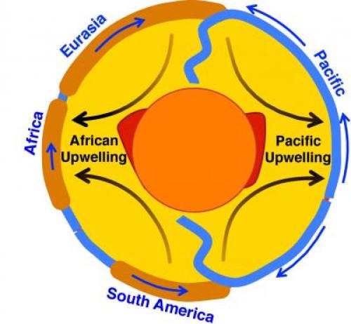
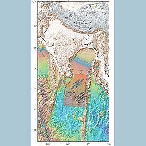
This is a diagram showing a slice through the Earth’s mantle, cutting across major mantle upwelling locations beneath Africa and the Pacific. (Credit: C. Conrad (UH SOEST))

Conrad has studied patterns of tectonic plates throughout his career, and has long noticed that the plates were, on average, moving northward. “Knowing this,” explained Conrad, “I was curious if I could determine a single location in the Northern Hemisphere toward which all plates are converging, on average.” After locating this point in eastern Asia, Conrad then wondered if other special points on Earth could characterize plate tectonics. “With some mathematical work, I described the plate tectonic ‘quadrupole’, which defines two points of ‘net convergence’ and two points of ‘net divergence’ of tectonic plate motions.”

When the researchers computed the plate tectonic quadruople locations for present-day plate motions, they found that the net divergence locations were consistent with the African and central Pacific locations where scientists think that mantle upwellings are occurring today. “This observation was interesting and important, and it made sense,” said Conrad. “Next, we applied this formula to the time history of plate motions and plotted the points — I was astonished to see that the points have not moved over geologic time!” Because plate motions are merely the surface expression of the underlying dynamics of the Earth’s mantle, Conrad and his colleagues were able to infer that upwelling flow in the mantle must also remain stable over geologic time. “It was as if I was seeing the ‘ghosts’ of ancient mantle flow patterns, recorded in the geologic record of plate motions!”

Earth’s mantle dynamics govern many aspects of geologic change on the Earth’s surface. This recent discovery that mantle upwelling has remained stable and centered on two locations (beneath Africa and the Central Pacific) provides a framework for understanding how mantle dynamics can be linked to surface geology over geologic time. For example, the researchers can now estimate how individual continents have moved relative to these two upwelling locations. This allows them to tie specific events that are observed in the geologic record to the mantle forces that ultimately caused these events.

More broadly, this research opens up a big question for solid earth scientists: What processes cause these two mantle upwelling locations to remain stable within a complex and dynamically evolving system such as the mantle? One notable observation is that the lowermost mantle beneath Africa and the Central Pacific seems to be composed of rock assemblages that are different than the rest of the mantle. Is it possible that these two anomalous regions at the bottom of the mantle are somehow organizing flow patterns for the rest of the mantle? How?

“Answering such questions is important because geologic features such as ocean basins, mountains belts, earthquakes and volcanoes ultimately result from Earth’s interior dynamics,” Conrad described. “Thus, it is important to understand the time-dependent nature of our planet’s interior dynamics in order to better understand the geological forces that affect the planetary surface that is our home.”

The mantle flow framework that can be defined as a result of this study allows geophysicists to predict surface uplift and subsidence patterns as a function of time. These vertical motions of continents and seafloor cause both local and global changes in sea level. In the future, Conrad wants to use this new understanding of mantle flow patterns to predict changes in sea level over geologic time. By comparing these predictions to observations of sea level change, he hopes to develop new constraints on the influence of mantle dynamics on sea level.

Edmontosaurus:Dinosaur Fossil With Fleshy Rooster’s Comb Is First of Its Kind

The structure above the fossil’s head was so unexpected that Phil Bell put his chisel straight through the middle of it. “I was just expecting there to be rock, and all of a sudden there was skin underneath, and I thought to myself, ‘Whoops,'” he said. What Bell had found was the first dinosaur fossil with a fleshy crest atop its head.

“We know that lots of dinosaurs had different kinds of head ornaments, but these are all made of bones,” said Bell, a paleontologist at the University of New England, Australia. “There’s never been any indication that any dinosaurs had something like this, so this was totally out of left field,” he said.

Bell was studying a mummified specimen of Edmontosaurus regalis that had been found preserved in a single sandstone boulder in the Wapiti Formation in Alberta, Canada. E. regalis is a member of the hadrosaurids, or duck-billed dinosaurs, that were common around 75 to 65 million years ago. Researchers had previously described bony crests in many hadrosaurids.

But CT scans revealed that the new fossil’s crest was made entirely out of soft tissue, similar to a rooster’s comb. “This was a real surprise,” Bell said. “Not only did we have skin associated with the head, but also this completely bizarre structure.” The results were published in the December 12 issue of Current Biology.

David Evans, vertebrate paleontology curator at the Royal Ontario Museum in Toronto, who was not involved with the study, said he agreed with Bell’s interpretation of the new fossil. “We have a better idea of what skin looked like on Edmontosaurus than probably any other dinosaur, but we rarely had a look at skin on the head until now, and that’s what makes this discovery so exciting,” he said. “I don’t think we would have expected Edmontosaurus, which is a relatively plain, unornamented dinosaur, to have such a flashy soft-tissue crest, so that came as a bit of a surprise,” Evans said.

A rare, mummified specimen of the duck-billed dinosaur Edmontosauraus regalis shows for the first time that those dinosaurs' heads were adorned with a fleshy comb, most similar to the roosters' red crest.

A rare, mummified specimen of the duck-billed dinosaur Edmontosauraus regalis shows for the first time that those dinosaurs’ heads were adorned with a fleshy comb, most similar to the roosters’ red crest.

Best Crest Gets the Girl

“I think it reminds us that even in dinosaurs that we think we know well, new discoveries can really change what we think about how these animals looked and behaved,” Evans said. The new specimen was particularly exciting because it gave researchers a glimpse into the social lives of dinosaurs, he said.

The presence of bony crests, frills, and horns in many dinosaur groups has long indicated that dinosaurs were very likely visual animals, Evans said. “This is a rare glimpse of a soft-tissue display structure, and it gets us thinking that maybe soft-tissue structures were potentially just as important as hard-tissue ones in terms of socio-sexual displays,” he said.

According to both Bell and Evans, the fleshy comb’s prominent position on the head is similar to that found today in birds such as roosters, grouse, and condors, and it’s possible it could have served a similar function. “They use these to get the girls, basically—to indicate how fertile and how strong the male is,” Bell said. Edmontosaurus was a herding animal, so the fleshy structure could also have been used to indicate the top male within the herd, he said. “Perhaps the male with the biggest and brightest crest was the leader of the pack, so to speak,” Bell said.

Opening the Door to More Soft-Tissue Finds

Unlike bones, soft tissue and skin are rarely preserved in fossils. “For the skin to preserve, these animals had to be buried very rapidly, probably within a day or two after they died, and the chemical environment in the sediment was just right,” Bell said.

There have been a number of other similarly “mummified” dinosaurs, including of Edmontosaurus, but none of them have had similar soft tissues around the skull. The new fossil’s fleshy crest could indicate that such soft-tissue structures may have been more prevalent than previously believed.

“The actual bones of Edmontosaurus have absolutely no indication that there’s a crest of any sort in this animal, so similar crests or other fleshy structures could have been really widespread among dinosaurs,” Bell said. “The fact that we have no evidence on the bones apparently means nothing about the external appearance of these animals,” he said.

The discovery could make paleontologists look more carefully for such fleshy structures among fossils, Bell said. “Paleontologists are always in a rush to expose the bone, because that’s seen as the most exciting thing,” he said. “Fossilized skin is far more delicate than the bones. To actually leave the skin intact requires a lot of patience and a lot of very detailed work when you’re preparing the specimen,” Bell said.

“Now that we’re seeing that dinosaurs could do anything in terms of the way they looked, perhaps people will be more open-minded when they’re actually excavating, because that’s the moment of discovery,” Bell said. “Feathered dinosaurs from China are a prime example. Before, those kinds of structures were overlooked, but once people recognized what they were actually looking at, that these were feathers, they started appearing all over the world,” he said.

(Related: “Pictures: Dinosaur’s Flashy Feathers Revealed.”)

The Royal Ontario Museum’s Evans said the new Edmontosaurus specimen emphasizes how important the soft-tissue anatomy can be for understanding the biology of extinct animals, as well as how they looked when they were alive. “A discovery like this makes you think about what else we’re not seeing in the fossil record. It kind of opens the door for even more bizarre dinosaur anatomies than we typically think of,” he said.

Source: nationalgeographic

Runaway Process Drives Intermediate-Depth Earthquakes

Stanford researchers have uncovered a vital clue about the mechanism behind a type of earthquake that originates deep within Earth and accounts for a quarter of all temblors worldwide, some of which are strong enough to pose a safety hazard.

Stanford scientists may have solved the mystery of what drives a type of earthquake that occurs deep within Earth and accounts for one in four quakes worldwide.

A 3D rendering of the tectonic plates (multicolored regions) in northern South America (coastline shown in yellow) shows the underlying Bucaramanga Nest, which experiences more intermediate-depth earthquakes than any place in the world. (Credit: Image courtesy of German Prieto)

A 3D rendering of the tectonic plates (multicolored regions) in northern South America (coastline shown in yellow) shows the underlying Bucaramanga Nest, which experiences more intermediate-depth earthquakes than any place in the world. (Credit: Image courtesy of German Prieto)

Known as intermediate-depth earthquakes, these temblors originate farther down inside Earth than shallow earthquakes, which take place in the uppermost layer of Earth’s surface, called the crust. The kinds of quakes that afflict California and most other places in the world are shallow earthquakes.

“Intermediate-depth earthquakes occur at depths of about 30 miles down to about 190 miles,” said Greg Beroza, a professor of geophysics at Stanford and a coauthor of a new study that will be published in an upcoming issue of the journal Geophysical Research Letters.

Unlike shallow earthquakes, the cause of intermediate quakes is not well-understood. Part of the problem is that the mechanism for shallow earthquakes should not physically work for quakes at greater depths.

“Shallow earthquakes occur when stress building up at faults overcomes friction, resulting in sudden slip and energy release,” Beroza said. “That mechanism shouldn’t work at the higher pressures and temperatures at which intermediate depth earthquakes occur.”

A better understanding of intermediate-depth quakes could help scientists forecast where they will occur and the risk they pose to buildings and people.

“They represent 25 percent of the catalog of earthquakes, and some of them are large enough to produce damage and deaths,” said study first author Germán Prieto, an assistant professor of geophysics at the Massachusetts Institute of Technology.

A tale of two theories

There are two main hypotheses for what may be driving intermediate depth earthquakes. According to one idea, water is squeezed out of rock pores at extreme depths and the liquid acts like a lubricant to facilitate fault sliding. This fits with the finding that intermediate quakes generally occur at sites where one tectonic plate is sliding, or subducting, beneath another.

“Typically, subduction involves oceanic plates whose rocks contain lots of water,” Beroza said.

A competing idea is that as rocks at extreme depths deform, they generate heat due to friction. The heated rocks become more malleable, or plastic, and as a result slide more easily against each other. This can create a positive feedback loop that further weakens the rock and increases the likelihood of fault slippage.

“It’s a runaway process in which the increasing heat generates more slip, and more slip generates more heat and so on,” Prieto said.

To distinguish between the two possible mechanisms, the scientists studied a site near the city of Bucaramanga in Colombia that boasts the highest concentration of intermediate quakes in the world. About 18 intermediate depth temblors rattle Bucaramanga every day. Most are magnitude 2 to 3, weak quakes that are detectable only by sensitive instruments.

But about once a month one occurs that is magnitude 5 or greater — strong enough to be felt by the city’s residents. Moreover, past studies have revealed that most of the quakes appear to be concentrated at a site located about 90 miles beneath Earth’s surface that scientists call the Bucaramanga Nest.

A natural laboratory

This type of clustering is highly unusual and makes the Bucaramanga Nest a “natural laboratory” for studying intermediate depth earthquakes. Comparison studies of intermediate quakes from different parts of the world are difficult because the makeup of Earth’s crust and mantle can vary widely by location.

In the Bucaramanga Nest, however, the intermediate quakes are so closely packed together that for the purposes of scientific studies and computer models, it’s as if they all occurred at the same spot. This vastly simplifies calculations, Beroza said.

“When comparing a magnitude 2 and a magnitude 5 intermediate depth earthquake that are far apart, you have to model everything, including differences in the makeup of the Earth’s surface,” he said. “But if they’re close together, you can assume that the seismic waves of both quakes suffered the same distortions as they traveled toward the Earth’s surface.”

By studying seismic waves picked up by digital seismometers installed on Earth’s surface above the Bucaramanga Nest, the scientists were able to measure two key parameters of the intermediate quakes happening deep underground.

One, called the stress drop, allowed the team to estimate the total amount of energy released during the fault slips that caused the earthquakes. The other was radiated energy, which is a measure of how much of the energy generated by the fault slip is actually converted to seismic waves that propagate through Earth to shake the surface.

Two things immediately stood out to the researchers. One was that the stress drop for intermediate quakes increased along with their magnitudes. That is, larger intermediate quakes released proportionally more total energy than smaller ones. Second, the amount of radiated energy released by intermediate earthquakes accounted for only a tiny portion of the total energy as calculated by the stress drop.

“For these intermediate-depth earthquakes in Colombia, the amount of energy converted to seismic waves is only a small fraction of the total energy,” Beroza said.

The implication is that intermediate earthquakes are expending most of their energy locally, likely in the form of heat.

“This is compelling evidence for a thermal runaway failure mechanism for intermediate earthquakes, in which a slipping fault generates heat. That allows for more slip and even more heat, and a positive feedback loop is created,” said study coauthor Sarah Barrett, a Stanford graduate student in Beroza’s research group.

Source: Stanford University (2013, December 11). Runaway process drives intermediate-depth earthquakes. ScienceDaily.

Tooth Structure and Wear Provide Clues to Ecology and Evolution of Ancient Marine Creatures

A trio of published studies have highlighted the importance of examining dental structure and wear in ancient creatures to better understand their ecology and evolution.

New York Institute of Technology College of Osteopathic Medicine Assistant Professor Brian Beatty, Ph.D., contributed to all three of the studies with his expertise in analyzing patterns of tooth wear and structure.

“Tooth wear is a permanent record — it shows the interaction of the animal and the world,” says Beatty, a paleontologist who teaches anatomy to more than 300 medical and health professions students. “By examining the adult structure of teeth, we can learn how different vertebrate groups have been able to modify aspects of their tooth development so they can achieve structures that serve functional purposes.”

Beatty says the findings in the three papers he contributed to may change perceptions of how some marine creatures lived in ancient times.

In the Zoological Journal of the Linnean Society, Beatty and colleagues from Brazil, Edinburgh, Scotland, snd the Museum of Jurassic Marine Life in Dorset, England, described a new species of ancient crocodile that had uniquely large sets of two different types of jaw muscles, enabling it catch and kill prey quickly with both speed and power. The study’s first author is Mark Young from the University of Edinburgh’s School of Geosciences.

Torvoneustes, the "savage swimmer" ancient crocodile had enlarged jaws closing muscles attached to both the roof of the mouth and the roof of the skull. (Credit: Dmitry Bogdanov)

Torvoneustes, the “savage swimmer” ancient crocodile had enlarged jaws closing muscles attached to both the roof of the mouth and the roof of the skull. (Credit: Dmitry Bogdanov)

Beatty also found that the skull of the dolphin-like species known as Torvoneustes (“savage swimmer”), was noticeably different than other creatures it is usually compared to. Most crocodiles have large bumps and pits in their skulls; Torvoneustes had a smooth skull that was lighter and reduced turbulence, which likely made it an agile swimmer, with movements more akin to a dolphin.

“These features we described could be another side of how extremely specialized these marine crocodiles were getting,” says Beatty.

In a paper published in the Netherlands Journal of Geosciences, Beatty and colleagues, including first author F.M. Holwerda, studied the teeth of a small lizard-like species known as mosasaur. The researchers found that the …-million-year-old creature had a different feeding pattern than that associated with most lizards. Rather than grabbing prey and swallowing it, this species was more likely a bottom feeder, feasting on hard-shelled crabs, clams, and sea urchins along sandy areas beneath the sea.

The third paper, published in Acta Palaeontologica Polonica, details the unique anatomy of the teeth of Teleosaurids, another group of crocodile-like marine creature that lived about 165 million years ago. Beatty and his colleagues, including first author Young, described new findings about “denticles” or tooth-like projections similar to serrated surfaces in their teeth and visible only through scanning electron microscopic analysis. Closer examinations of the teeth, he said, mean that the creature perhaps had a larger role in its ecosystem beyond “being a croc simply snapping at things,” Beatty said.

“The findings of the three papers confirm that the interactions of marine vertebrates in the past with each other and with their environment were just as complex as they are now,” says Beatty. “Superficial resemblances do not define an animal’s lifestyle — the beauty of evolution is this diversity and you see how natural selection drives evolution. There are situations where animals are deriving new organs, tissues, and molecules and they’re doing that to deal with problems posed by natural selection. ”

Beatty is one of six paleontologists in the College of Osteopathic Medicine’s Department of Anatomy. He and Associate Professor Matthew Mihlbachler launched the online Dental Microwear Image Library containing thousands of magnified images of tooth surfaces that other scientists can use to establish hypotheses about ecological conditions in prehistoric times.

Source:  New York Institute of Technology (2013, December 12). Tooth structure and wear provide clues to ecology and evolution of ancient marine creatures. ScienceDaily. Retrieved December 13, 2013, from http://www.sciencedaily.com­/releases/2013/12/131212132408.htm

Lithosphere Deformed And Fractured Under Indian Ocean Much Earlier Than Previously Thought

The discovery by Indian and British scientists that the Earth’s strong outer shell – the ‘lithosphere’ – within the central Indian Ocean began to deform and fracture 15.4–13.9 million years ago, much earlier than previously thought, impacts our understanding of the birth of the Himalayas and the strengthening of the Indian-Asian monsoon.

India and Asia collided around 50 million years ago as a result of plate tectonics – the large-scale movements of the lithosphere, which continue to this day. The new study, published in the scientific journal Geology, focuses on the tectonics-related deformation of the lithosphere below the central Indian Ocean.

The discovery by Indian and British scientists that the Earth's strong outer shell -- the 'lithosphere' -- within the central Indian Ocean began to deform and fracture 15.4--13.9 million years ago, much earlier than previously thought, impacts our understanding of the birth of the Himalayas and the strengthening of the Indian-Asian monsoon. (Credit: Image courtesy of National Oceanography Centre, Southampton)

The discovery by Indian and British scientists that the Earth’s strong outer shell — the ‘lithosphere’ — within the central Indian Ocean began to deform and fracture 15.4–13.9 million years ago, much earlier than previously thought, impacts our understanding of the birth of the Himalayas and the strengthening of the Indian-Asian monsoon. (Credit: Image courtesy of National Oceanography Centre, Southampton)

“Compression of the lithosphere has caused large-scale buckling and cracking,” says team member Professor Jon Bull of the University of Southampton’s School of Ocean and Earth Science based at the National Oceanography Centre; “The ocean floor has been systematically transformed into folds 100-300 kilometres long and 2,000-3,000 metres high, and there are also regularly spaced faults or fractures that are evident from seismic surveys and ocean drilling.”

The onset of this deformation marks the start of major geological uplift of the Himalayas and the Tibetan Plateau, some 4,000 km further to the north, due to stresses within the wider India-Asia area. Some studies indicate that it began around 8.0–7.5 million years ago, while others have indicated that it started before 8.0 million years ago, and perhaps much earlier.

This controversy has now been addressed by Professor Bull and his colleagues Dr Kolluru Krishna of the National Institute of Oceanography in India, and Dr Roger Scrutton of Edinburgh University. They have analysed seismic profiles of 293 faults in the accumulated sediments of the Bengal Fan. This is the world’s largest submarine fan, a delta-shaped accumulation of land-derived sediments covering the floor of the Bay of Bengal.

They demonstrate that deformation of the lithosphere within the central Indian Ocean started around 15.4–13.9 million years ago, much earlier than most previous estimates. This implies considerable Himalayan uplift before 8.0 million years ago, which is when many geologists believe that the strong seasonal winds of the India-Asia monsoon first started.

“However,” says Professor Bull, “the realisation that the onset of lithospheric deformation within the central Indian Ocean occurred much earlier fits in well with more recent evidence that the strengthening of the monsoon was linked to the early geological uplift of the Himalayas and Tibetan plateau up to 15-20 million years ago.”

Intensive deep-sea drilling within the Bengal Fan should provide better age estimates for the onset of deformation of the lithosphere in the central Indian Ocean and help settle the controversy.

The research was funded by India’s Council of Scientific and Industrial Research (CSIR), and the United Kingdom’s Royal Society and Natural Environment Research Council (NERC).

Western Indian Ocean Earthquake and Tsunami Hazard Potential Greater Than Previously Thought

Earthquakes similar in magnitude to the 2004 Sumatra earthquake could occur in an area beneath the Arabian Sea at the Makran subduction zone, according to recent research published in Geophysical Research Letters.

The research was carried out by scientists from the University of Southampton based at the National Oceanography Centre Southampton (NOCS), and the Pacific Geoscience Centre, Natural Resources Canada.

The study suggests that the risk from undersea earthquakes and associated tsunami in this area of the Western Indian Ocean — which could threaten the coastlines of Pakistan, Iran, Oman, India and potentially further afield — has been previously underestimated. The results highlight the need for further investigation of pre-historic earthquakes and should be fed into hazard assessment and planning for the region.

Subduction zones are areas where two of Earth’s tectonic plates collide and one is pushed beneath the other. When an earthquake occurs here, the seabed moves horizontally and vertically as the pressure is released, displacing large volumes of water that can result in a tsunami.

Makran map earthquakes. (Credit: Image courtesy of National Oceanography Centre)

Makran map earthquakes. (Credit: Image courtesy of National Oceanography Centre)

The Makran subduction zone has shown little earthquake activity since a magnitude 8.1 earthquake in 1945 and magnitude 7.3 in 1947. Because of its relatively low seismicity and limited recorded historic earthquakes it has often been considered incapable of generating major earthquakes.

Plate boundary faults at subduction zones are expected to be prone to rupture generating earthquakes at temperatures of between 150 and 450 °C. The scientists used this relationship to map out the area of the potential fault rupture zone beneath the Makran by calculating the temperatures where the plates meet. Larger fault rupture zones result in larger magnitude earthquakes.

“Thermal modelling suggests that the potential earthquake rupture zone extends a long way northward, to a width of up to 350 kilometres which is unusually wide relative to most other subduction zones,” says Gemma Smith, lead author and PhD student at University of Southampton School of Ocean and Earth Science, which is based at NOCS.

The team also found that the thickness of the sediment on the subducting plate could be a contributing factor to the magnitude of an earthquake and tsunami there.

“If the sediments between the plates are too weak then they might not be strong enough to allow the strain between the two plates to build up,” says Smith. “But here we see much thicker sediments than usual, which means the deeper sediments will be more compressed and warmer. The heat and pressure make the sediments stronger. This results in the shallowest part of the subduction zone fault being potentially capable of slipping during an earthquake.

“These combined factors mean the Makran subduction zone is potentially capable of producing major earthquakes, up to magnitude 8.7-9.2. Past assumptions may have significantly underestimated the earthquake and tsunami hazard in this region.”

Cockroaches Probably Cleaned Up after Dinosaurs

Dinosaurs undoubtedly produced huge quantities of excrements. But who cleaned up after them? Dung beetles and flies with rapid development were rare during most of the Mesozoic. Candidates for these duties are extinct cockroaches (Blattulidae), whose temporal range is associated with herbivorous dinosaurs. An opportunity to test this hypothesis arises from coprolites to some extent extruded from an immature cockroach preserved in the amber of Lebanon, studied using synchrotron X-ray microtomography. 1.06% of their volume is filled by particles of wood with smooth edges, in which size distribution directly supports their external pre-digestion. Because fungal pre-processing can be excluded based on the presence of large particles (combined with small total amount of wood) and absence of damages on wood, the likely source of wood are herbivore feces. Smaller particles were broken down biochemically in the cockroach hind gut, which indicates that the recent lignin-decomposing termite and cockroach endosymbionts might have been transferred to the cockroach gut upon feeding on dinosaur feces.

Dinosaur-age cockroach of the extinct family Blattulidae. show more  (A – head to leg end length: 3.8 mm) with antennal sensory system (B, C) and five preserved coprolites (D – optical, E – surface rendering of numbered coprolites and dense particles based on the image stack from synchrotron X-ray microtomography; F – ST orthoslice with labelled boundaries and fragments). Lebanon amber 1094A-I. Scales 0,5 mm.  doi:10.1371/journal.pone.0080560.g001

Dinosaur-age cockroach of the extinct family Blattulidae.
(A – head to leg end length: 3.8 mm) with antennal sensory system (B, C) and five preserved coprolites (D – optical, E – surface rendering of numbered coprolites and dense particles based on the image stack from synchrotron X-ray microtomography; F – ST orthoslice with labelled boundaries and fragments). Lebanon amber 1094A-I. Scales 0,5 mm.
doi:10.1371/journal.pone.0080560.g001


Dinosaur-age wood decomposing cockroach with coprolite and its ecological context. show more  A) wood fragment no. 123 (coprolite no. 3), volume 23077 µm3 (TRC- parenchymatous tangential ray cells); B) Lebanese amber (Blattulidae 1094A-I), length (head to leg end): 3.8 mm; C) a virtual synchrotron section (~1.2 mm) through coprolite no. 3, wood particles are pale; D) percentual representation of volume of the respective wood particles; E) distribution analysis of simple particle count of 280 wood fragments present in all five coprolites plotted over the fragment size; F) Ratios of the Blattulidae and “Voltziablatta”- group – families that replaced each other during the Triassic (interrupted arrow) – to all cockroaches, plotted over the timescale (in Ma). The origin and extinction of dinosaurs are pointed with arrows. “N in %” means percentual representation of number of specimens, “spp in %” is a percentual representation of species. Original data.  doi:10.1371/journal.pone.0080560.g002

Dinosaur-age wood decomposing cockroach with coprolite and its ecological context.
A) wood fragment no. 123 (coprolite no. 3), volume 23077 µm3 (TRC- parenchymatous tangential ray cells); B) Lebanese amber (Blattulidae 1094A-I), length (head to leg end): 3.8 mm; C) a virtual synchrotron section (~1.2 mm) through coprolite no. 3, wood particles are pale; D) percentual representation of volume of the respective wood particles; E) distribution analysis of simple particle count of 280 wood fragments present in all five coprolites plotted over the fragment size; F) Ratios of the Blattulidae and “Voltziablatta”- group – families that replaced each other during the Triassic (interrupted arrow) – to all cockroaches, plotted over the timescale (in Ma). The origin and extinction of dinosaurs are pointed with arrows. “N in %” means percentual representation of number of specimens, “spp in %” is a percentual representation of species. Original data.
doi:10.1371/journal.pone.0080560.g002


Citation: Vršanský P, van de Kamp T, Azar D, Prokin A, Vidlička L, et al. (2013) Cockroaches Probably Cleaned Up after Dinosaurs. PLoS ONE 8(12): e80560. doi:10.1371/journal.pone.0080560

Editor: Ulrich Joger, State Natural History Museum, Germany

Why beaks evolved in some theropod dinosaurs and what their function : New Study

Why beaks evolved in some theropod dinosaurs and what their function might have been is the subject of new research by an international team of palaeontologists published this week in PNAS (Proceedings of the National Academy of Sciences).

Beaks are a typical hallmark of modern birds and can be found in a huge variety of forms and shapes. However, it is less well known that keratin-covered beaks had already evolved in different groups of dinosaurs during the Cretaceous Period.

Employing high-resolution X-ray computed tomography (CT scanning) and computer simulations, Dr Stephan Lautenschlager and Dr Emily Rayfield of the University of Bristol with Dr Perle Altangerel (National University of Ulaanbaatar) and Professor Lawrence Witmer (Ohio University) used digital models to take a closer look at these dinosaur beaks.

Computer models of the skull of Erlikosaurus andrewsi without (left) and with keratinous beak (right); colour plots resulting from finite element analysis show the degree of deformation in the different skull configurations. (Credit: Image by Dr Stephan Lautenschlager)

Computer models of the skull of Erlikosaurus andrewsi without (left) and with keratinous beak (right); colour plots resulting from finite element analysis show the degree of deformation in the different skull configurations. (Credit: Image by Dr Stephan Lautenschlager)

The focus of the study was the skull of Erlikosaurus andrewsi, a 3-4m (10-13ft) large herbivorous dinosaur called a therizinosaur, which lived more than 90 million years ago during the Cretaceous Period in what is now Mongolia, and which shows evidence that part of its snout was covered by a keratinous beak.

This new study reveals that keratinous beaks played an important role in stabilizing the skeletal structure during feeding, making the skull less susceptible to bending and deformation.

Lead author Dr Stephan Lautenschlager of Bristol’s School of Earth Sciences said: “It has classically been assumed that beaks evolved to replace teeth and thus save weight, as a requirement for the evolution of flight. Our results, however, indicate that keratin beaks were in fact beneficial to enhance the stability of the skull during biting and feeding.”

Co-author Dr Emily Rayfield, Reader of Palaeobiology at Bristol said: “Using Finite Element Analysis, a computer modelling technique routinely used in engineering, we were able to deduce very accurately how bite and muscle forces affected the skull of Erlikosaurus during the feeding process. This further allowed us to identify the importance of soft-tissue structures, such as the keratinous beak, which are normally not preserved in fossils.”

Co-author Lawrence Witmer, Chang Professor of Paleontology at the Ohio University Heritage College of Osteopathic Medicine said: “Beaks evolved several times during the transitions from dinosaurs to modern birds, usually accompanied by the partial or complete loss of teeth and our study now shows that keratin-covered beaks represent a functional innovation during dinosaur evolution.”

This work was funded by a research fellowship to Stephan Lautenschlager from the German Volkswagen Foundation and grants from the National Science Foundation to Lawrence Witmer.

Expedition to Undersea Mountain Yields New Information About Sub-Seafloor Structure

Scientists recently concluded an expedition aboard the research vessel JOIDES Resolution to learn more about Atlantis Massif, an undersea mountain, or seamount, that formed in a very different way than the majority of the seafloor in the oceans.

Unlike volcanic seamounts, which are made of the basalt that’s typical of most of the seafloor, Atlantis Massif includes rock types that are usually only found much deeper in the ocean crust, such as gabbro and peridotite.

Atlantis Massif, showing the fault that borders this Atlantic Ocean seamount. (Credit: NOAA)

Atlantis Massif, showing the fault that borders this Atlantic Ocean seamount. (Credit: NOAA)

The expedition, known as Integrated Ocean Drilling Program (IODP) Expedition 340T, marks the first time the geophysical properties of gabbroic rocks have successfully been measured directly in place, rather than via remote techniques such as seismic surveying.

With these measurements in hand, scientists can now infer how these hard-to-reach rocks will “look” on future seismic surveys, making it easier to map out geophysical structures beneath the seafloor.

“This is exciting because it means that we may be able to use seismic survey data to infer the pattern of seawater circulation within the deeper crust,” says Donna Blackman of the Scripps Institution of Oceanography in La Jolla, Calif., co-chief scientist for Expedition 340T.

“This would be a key step for quantifying rates and volumes of chemical, possibly biological, exchange between the oceans and the crust.”

Atlantis Massif sits on the flank of an oceanic spreading center that runs down the middle of the Atlantic Ocean.

As the tectonic plates separate, new crust is formed at the spreading center and a combination of stretching, faulting and the intrusion of magma from below shape the new seafloor.

Periods of reduced magma supplied from the underlying mantle result in the development of long-lived, large faults. Deep portions of the crust shift upward along these faults and may be exposed at the seafloor.

This process results in the formation of an oceanic core complex, or OCC, and is similar to the processes that formed the Basin and Range province of the Southwest United States.

“Recent discoveries from scientific ocean drilling have underlined that the process of creating new oceanic crust at seafloor spreading centers is complex,” says Jamie Allan, IODP program director at the U.S. National Science Foundation (NSF), which co-funds the program.

“This work significantly adds to our ability to infer ocean crust structure and composition, including predicting how ocean crust has ‘aged’ in an area,” says Allan, “thereby giving us new tools for understanding ocean crust creation from Earth’s mantle.”

Atlantis Massif is a classic example of an oceanic core complex.

Because it’s relatively young–formed within the last million years–it’s an ideal place, scientists say, to study how the interplay between faulting, magmatism and seawater circulation influences the evolution of an OCC within the crust.

“Vast ocean basins cover most of the Earth, yet their crust is formed in a narrow zone,” says Blackman. “We’re studying that source zone to understand how rifting and magmatism work together to form a new plate.”

The JOIDES Resolution first visited Atlantis Massif about seven years ago; the science team on that expedition measured properties in gabbro.

But they focused on a shallower section, where pervasive seawater circulation had weathered the rock and changed its physical properties.

For the current expedition, the team did not drill new holes.

Rather, they lowered instruments into a deep existing hole drilled on a previous expedition, and made measurements from inside the hole.

The new measurements, at depths between 800 and 1,400 meters (about 2,600-4,600 feet) below the seafloor, include only a few narrow zones that had been altered by seawater circulation and/or by fault slip deformation.

The rest of the measurements focused on gabbroic rocks that have remained unaltered thus far.

The properties measured in the narrow zones of altered rock differ from the background properties measured in the unaltered gabbroic rocks.

The team found small differences in temperature next to two sub-seafloor faults, which suggests a slow percolation of seawater within those zones.

There were also significant differences in the speed at which seismic waves travel through the altered vs. unaltered zones.

“The expedition was a great opportunity to ground-truth our recent seismic analysis,” says Alistair Harding, also from the Scripps Institution of Oceanography and a co-chief scientist for Expedition 340T.

“It also provides vital baseline data for further seismic work aimed at understanding the formation and alteration of the massif.”

Deep-Sea Study Reveals Cause of 2011 Tsunami: Unusually Thin, Slippery Geological Fault Found

The devastating tsunami that struck Japan’s Tohoku region in March 2011 was touched off by a submarine earthquake far more massive than anything geologists had expected in that zone.

Now, a team of scientists including McGill University geologist Christie Rowe, has published a set of studies in the journal Science that shed light on what caused the dramatic displacement of the seafloor off the northeastern coast of Japan. The findings also suggest that other zones in the northwest Pacific may be at risk of similar huge earthquakes.

An international team of scientists has concluded that an unusually thin and slippery geological fault where the North American plate rides over the edge of the Pacific plate caused a massive displacement of the seafloor off the coast of Japan in March 2011, touching off the devastating tsunami that struck the Tohoku region. (Credit: JAMSTEC/IODP)

An international team of scientists has concluded that an unusually thin and slippery geological fault where the North American plate rides over the edge of the Pacific plate caused a massive displacement of the seafloor off the coast of Japan in March 2011, touching off the devastating tsunami that struck the Tohoku region. (Credit: JAMSTEC/IODP)

Prof. Rowe, of McGill’s Department of Earth & Planetary Sciences, was one of 27 scientists from 10 countries who participated in a 50-day expedition in 2012 on the Japanese drilling vessel Chikyu. The team drilled three holes in the Japan Trench area to study the rupture zone of the 2011 earthquake, a fault in the ocean floor where two of Earth’s major tectonic plates meet, deep beneath the surface of the Pacific Ocean.

The joint where the Pacific and North American plates meet forms what is known as a “subduction” zone, with the North American plate riding over the edge of the Pacific plate. The latter plate bends and plunges deep into Earth, forming the Japan Trench.

The conventional view among geologists has been that deep beneath the seafloor, where rocks are strong, movements of the plates can generate a lot of elastic rebound. Closer to the surface of the seafloor, where rocks are softer and less compressed, this rebound effect was thought to taper off.

Until 2011, the largest displacement of plates ever recorded along a fault occurred in 1960 off the coast of Chile, where a powerful earthquake displaced the seafloor plates by an average of 20 metres. In the Tohoku earthquake, the slip amounted to 30 to 50 metres — and the slip actually grew bigger as the subterranean rupture approached the seafloor. This runaway rupture thrust up the seafloor, touching off the horrifying tsunami.

The results of last year’s drilling by the Chikyu expedition, outlined in the Science papers published Dec. 6, reveal several factors that help account for this unexpectedly violent slip between the two tectonic plates.

For one thing, the fault, itself, is very thin — less than five metres thick in the area sampled. “To our knowledge, it’s the thinnest plate boundary on Earth,” Rowe says. By contrast, California’s San Andreas fault is several kilometers thick in places.

The scientists also discovered that the clay deposits that fill the narrow fault are made of extremely fine sediment. “It’s the slipperiest clay you can imagine,” says Rowe. “If you rub it between your fingers, it feels like a lubricant.”

The discovery of this unusual clay in the Tohoku slip zone suggests that other subduction zones in the northwest Pacific where this type of clay is present — from Russia’s Kamchatka peninsula to the Aleutian Islands — may be capable of generating similar, huge earthquakes, Rowe adds.

To conduct the studies, the scientists used specially designed deep-water drilling equipment that enabled them to drill more than 800 metres beneath the sea floor, in an area where the water is around 6,900 metres deep. No hole had ever before been drilled that deep in an area of similar water depth. At those extraordinary depths, it took six hours from the time the drill pulled core samples from the fault until it reached the ship.

During night shifts on deck, Rowe was in charge of deciding which sections of drill core would go to geochemists for water sampling, and which would go to geologists for studies of the sediment and deformation structures. “We X-rayed the core as soon as it came on board, so the geochemists could get their water sample before oxygen was able to penetrate inside the pores of the sediment.”

The expedition was supported by member countries of the Integrated Ocean Drilling Program (particularly Japan and the US), and Canadian participants were supported by the European Consortium for Ocean Research Drilling, of which Canada is a member.